Antipaxos
Native name: Αντίπαξος or Αντίπαξοι | |
|---|---|
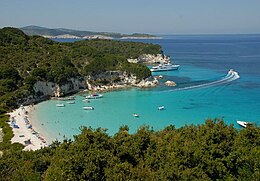
 Voutoumi beach at Antipaxoi, Greece. | |
 | |
| Geography | |
| Coordinates | 39°08′57.40″N 20°13′53.98″E / 39.1492778°N 20.2316611°E |
| Administration | |


Antipaxos (Greek: Αντίπαξος, pronounced [ɐnˈdipɐksos]) is a small island (5 km²) in Greece, about 3 kilometres (2 miles) to the south of Paxos. It is administratively part of the municipality of Paxoi in Corfu regional unit in western Greece. As of 2011[update], the resident population of the island was 20.[1] Largely covered in vineyards, Antipaxos has several beaches and one harbour, Agrapidia.
It has three main beaches: Vrika (white sand), Mesovrika (pebbles) and Voutoumi (pebbles) and it can be reached by 15-minute ride with a sea-taxi from the port of Gaios in Paxos.
References
- ^ "Detailed census results 2011" (in Greek). National Statistical Service of Greece. Archived from the original (xls 2,7 MB) on 2013-12-25.
External links
Wikimedia Commons has media related to Antipaxos.
