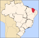
Iguatu
Appearance
Iguatu | |
|---|---|
 Location in Ceará state | |
| Coordinates: 06°21′32″S 39°17′56″W / 6.35889°S 39.29889°W | |
| Country | Brazil |
| Region | Northeast |
| State | Ceará |
| Population (2018 est.[1]) | |
• Total | 103,255 |
| Time zone | UTC-03:00 (BRT) |
Iguatu is a city in Ceará, a Brazilian State, with a population of 103,255 (2018 est.).[1] Agenor Neto is the city's mayor.
History
A village of Quixelôs Indians existed at this site before the arrival of the Portuguese. In 1707 the Society of Jesus began Western settlement here. It has been classed as a city since 1874. It is the seat of the Roman Catholic Diocese of Iguatu.
Transportation
Iguatu is served by Dr. Francisco Tomé da Frota Airport.
Notable native or resident
- Eleazar de Carvalho - Conductor and composer.
References
This article needs additional citations for verification. (August 2019) |
- ^ a b "Brazilian Institute of Geography and Statistics" (PDF). 2018. Retrieved 6 March 2019.
2018 Estimates of Population
External links


