
Fur (island)
This article needs additional citations for verification. (November 2007) |
Fur (alternative older spelling Fuur) is a small Danish island in the Limfjord at the northern tip of the Salling peninsula. Fur has under 900 inhabitants. The island covers an area of 22 km². It is located at 56°49′N 09°01′E / 56.817°N 9.017°E.
The island is linked to the mainland through a 24-hour ferry, the Sleipner-Fur ferry, sailing from Branden. The crossing of the Fursund takes 3–4 minutes.[1]
The island is renowned for its deposits of diatomite, known in Danish as moler which is used for cat litter. Fossil hunting is a popular activity on the island, and the fossils one can find in the moler can be more than 55 million years old.[2] Fur museum on the island features exhibits relating to the island, particularly fossils.
In 2010, readers of the Danish newspaper Kristeligt Dagblad voted for "Denmark's most wonderful island" and chose Fur ahead of Læsø and Ærø.[3]
Fur is part of Skive municipality.
-
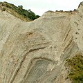 Image showing the distinct geological layers.
 -
 An inland location.
 -
 These cliffs of Fur have been a rich source of fossils.
 -
 Fur's location.


.svg)
See also
References
- ^ "Fursund turistinformation - Fursund Ferry Service". Archived from the original on 2007-04-26. Retrieved 2008-04-14.
- ^ "Fursund turistinformation - Fossil Hunting". Archived from the original on 2007-06-09. Retrieved 2008-04-14.
- ^ http://www.berlingske.dk/danmark/her-er-danmarks-skoenneste-oe
External links
| Baltic Sea | ||
|---|---|---|
| Sydhavsøerne | ||
| Kattegat | ||
| South Funen Archipelago | ||
| Limfjorden | ||
| Øresund | ||
| Great Belt | ||
| Little Belt | ||
| Wadden Sea | ||
| Other islands |
| |
56°50′N 9°01′E / 56.833°N 9.017°E
This Danish location article is a stub. You can help Wikipedia by expanding it. |