Gê'gyai County
Gê'gyai County
革吉县 • དགེ་རྒྱས་རྫོང་། | |
|---|---|
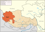
 Location of Gê'gyai County (red) within Ngari Prefecture (yellow) and the Tibet Autonomous Region | |
| Coordinates: 31°57′21″N 81°56′53″E / 31.95583°N 81.94806°E | |
| Country | People's Republic of China |
| Autonomous region | Tibet |
| Prefecture | Ngari Prefecture |
| Time zone | UTC+8 (China Standard) |
Gê'gyai County (Tibetan: དགེ་རྒྱས་རྫོང་།, Wylie: dge rgyas rdzong, ZYPY: Gê'gyai Zong, literally "Full Beauty", Chinese: 革吉县; pinyin: Géjí Xiàn) is a county in Ngari Prefecture of the Tibet Autonomous Region, China.
Lake Donggu (洞古错; 洞古錯; dònggǔcuò is located in Gê'gyai County.
Demography
Population of this district was 12,313 inhabitants in 1999.[1]
Notes and references
- ^ National Population Statistics Materials by County and City - 1999 Period, in China County & City Population 1999, Harvard China Historical GIS


