Cooking Lake (Alberta)
Appearance
| Cooking Lake | |
|---|---|
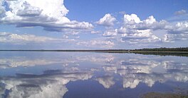
 From South Cooking Lake | |
| Location | Strathcona County, Alberta |
| Coordinates | 53°25′59″N 113°01′45″W / 53.43306°N 113.02917°W |
| Basin countries | Canada |
| Max. length | 5.3 km (3.3 mi) |
| Max. width | 12 km (7.5 mi) |
| Surface area | 36 km2 (14 sq mi) |
| Average depth | 1.7 m (5 ft 7 in) |
| Max. depth | 4.6 m (15 ft) |
| Surface elevation | 737 m (2,418 ft) |
| Settlements | North Cooking Lake South Cooking Lake |
| References | Cooking Lake |
Cooking Lake is a lake in Alberta.[1] It is located in Strathcona County, east-southeast of Edmonton. Edmonton/Cooking Lake Water Aerodrome is located on this lake.
Cooking Lake's name is an accurate preservation of its native Cree Indian name.[2]
References
- ^ "Cooking Lake". Geographical Names Data Base. Natural Resources Canada.
- ^ Place-names of Alberta. Ottawa: Geographic Board of Canada. 1928. p. 37.

