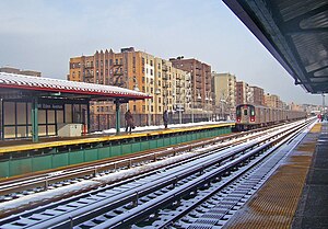
Mount Eden Avenue station
Mount Eden Avenue | |||||||
|---|---|---|---|---|---|---|---|
 | |||||||
| Station statistics | |||||||
| Address | Mount Eden Avenue & Jerome Avenue Bronx, NY 10452 | ||||||
| Borough | The Bronx | ||||||
| Locale | Highbridge | ||||||
| Coordinates | 40°50′39″N 73°54′53″W / 40.844268°N 73.914814°W | ||||||
| Division | A (IRT)[1] | ||||||
| Line | IRT Jerome Avenue Line | ||||||
| Services | 4 | ||||||
| Structure | Elevated | ||||||
| Platforms | 2 side platforms | ||||||
| Tracks | 3 | ||||||
| Other information | |||||||
| Opened | June 2, 1917 | ||||||
| Opposite- direction transfer | Yes | ||||||
| Traffic | |||||||
| 2023 | 990,912[2] | ||||||
| Rank | 295 out of 423[2] | ||||||
| Station succession | |||||||
| Next north | Template:NYCS next | ||||||
| Next south | Template:NYCS next | ||||||
| |||||||
| |||||||
| |||||||
Mount Eden Avenue is a local station on the IRT Jerome Avenue Line of the New York City Subway. Located at the intersection of Mount Eden and Jerome Avenues in the Bronx, it is served by the 4 train at all times.
History
This station opened with the first part of the Jerome Avenue Line on June 2, 1917 as a shuttle service between Kingsbridge Road and 149th Street. Only the southbound platform was in use at Kingsbridge Road.[4][5] This was in advance of through service to the IRT Lexington Avenue Line, which began on July 17, 1918.[6] This station was rehabilitated in 2004 with new canopies and windscreens.
Station layout
| Platform level | Side platform | |
| Northbound local | ← | |
| Peak-direction express | ← | |
| Southbound local | | |
| Side platform | ||
| Mezzanine | Fare control, station agent, MetroCard and OMNY machines | |
| Ground | Street level | Entrances/exits |

This elevated station has three tracks and two side platforms with the center express track not used in revenue service.[7] The original IRT-era signs are painted over and covered up with more contemporary Helvetica signs.
The 2006 artwork here is called The Procession of Folk, No. 3 by Amir Bey.
Exits
The station house is directly under the platforms and tracks. It has two staircases going up to each platform, a waiting area/crossunder, turnstile bank, token booth, and two street stairs going down to the northern corners of Mount Eden and Jerome Avenues. The eastern staircase faces south while the western one faces north. The northern edge of the station is visible from the Cross Bronx Expressway, especially for drivers in the northbound/eastbound lanes.[8]
References
- ^ "Glossary". Second Avenue Subway Supplemental Draft Environmental Impact Statement (SDEIS) (PDF). Vol. 1. Metropolitan Transportation Authority. March 4, 2003. pp. 1–2. Archived from the original (PDF) on February 26, 2021. Retrieved January 1, 2021.
- ^ a b "Annual Subway Ridership (2018–2023)". Metropolitan Transportation Authority. 2023. Retrieved April 20, 2024.
- ^ "Annual Subway Ridership (2018–2023)". Metropolitan Transportation Authority. 2023. Retrieved April 20, 2024.
- ^ "www.nycsubway.org: Service Begun on the Jerome Avenue Line (1917)". www.nycsubway.org. June 1, 1905. Retrieved September 6, 2016.
- ^ "Annual report. 1916-1917". HathiTrust. Interborough Rapid Transit Company. December 12, 2013. Retrieved September 5, 2016.
- ^ Brooklyn Daily Eagle Almanac. Brooklyn Daily Eagle. 1922. p. 372.
- ^ Dougherty, Peter (2020). Tracks of the New York City Subway 2020 (16th ed.). Dougherty. OCLC 1056711733.
- ^ "MTA Neighborhood Maps: University Heights" (PDF). Metropolitan Transportation Authority. 2015. Retrieved October 7, 2015.
External links
- nycsubway.org – IRT Woodlawn Line: Mt. Eden Avenue
- nycsubway.org — The Procession of Folk, No. 3 Artwork by Amir Bey (2006)
- Station Reporter — 4 Train
- The Subway Nut — Mount Eden Avenue Pictures
- MTA's Arts For Transit — Mount Eden (IRT Jerome Avenue Line)
- Mount Eden Avenue entrance from Google Maps Street View
- Platforms from Google Maps Street View


