
Kumbarilla, Queensland
| Kumbarilla Queensland | |||||||||||||||
|---|---|---|---|---|---|---|---|---|---|---|---|---|---|---|---|
 Kumbarilla | |||||||||||||||
| Coordinates | 27°18′57″S 150°52′34″E / 27.3158°S 150.8761°E | ||||||||||||||
| Population | 197 (2016 census)[1] | ||||||||||||||
| • Density | 0.7893/km2 (2.044/sq mi) | ||||||||||||||
| Postcode(s) | 4405 | ||||||||||||||
| Area | 249.6 km2 (96.4 sq mi) | ||||||||||||||
| Location | |||||||||||||||
| LGA(s) | Western Downs Region | ||||||||||||||
| State electorate(s) | Warrego | ||||||||||||||
| Federal division(s) | Maranoa | ||||||||||||||
| |||||||||||||||
Kumbarilla is a town and rural locality in the Western Downs Region, Queensland, Australia.[2][3] In the 2016 census, Kumbarilla had a population of 197 people.[1]
Geography
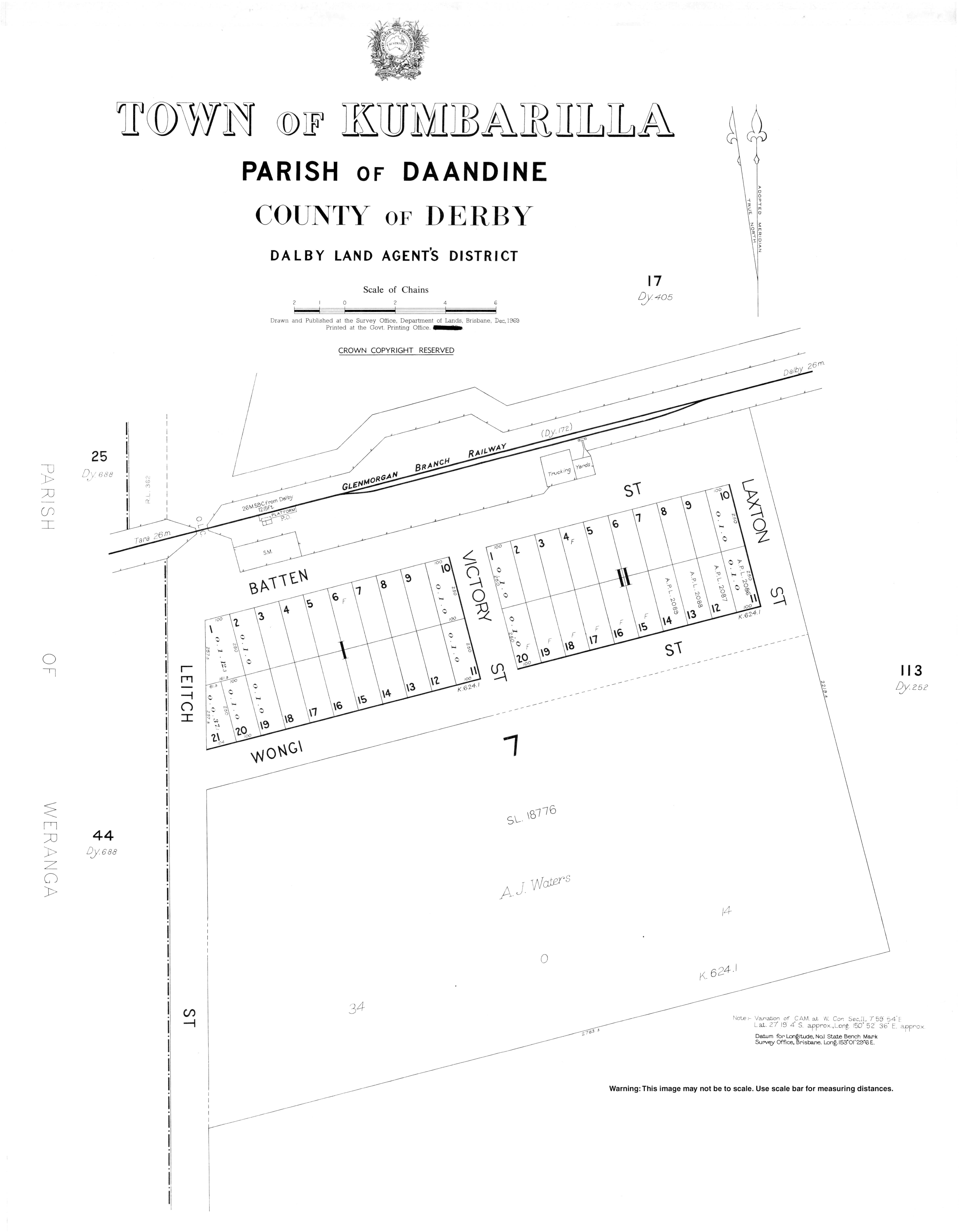
The locality ranges from 350m to 400m above sea level. The town is located in the south-west corner of the locality immediately to the south of the Kumbarilla railway station (27°18′54″S 150°52′34″E / 27.3150°S 150.8761°E) on the Glenmorgan railway line; there are very few buildings in the surveyed town plan area.[4][5]
The Glenmorgan railway line passes from east (Ducklo) to south-west (Weranga) through the southern part of the locality. The Moonie Highway also passes from the south-east (Ducklo) to the south (Marmadua), always south of the railway line and does not pass through the town; the junction of the highway with the Surat Developmental Road is at the south-western edge of the locality.[4]
The Braemer State Forest is in the north-west of the locality. In addition, there are two smaller state forests in the locality: Daandine State Forest and Weranga State Forest. Apart from these, the land is predominantly freehold used for grazing.[4]
Despite its name, the Kumbarilla State Forest is not within Kumbarilla but is immediately to the south of Kumbarilla's southern border in Marmadua and Halliford.[4]
Geologically Kumbarilla is part of the Surat Basin.
History
The town takes its name from its railway station which was in turn an Aboriginal word in a local dialect meaning ironbark tree/timber.[2][6]
Kumbarilla Provisional School opened in 1913 and became Kumbarilla State School on 1 December 1918. The school closed about 1923.[7]
In March 1918, the Queensland government offered 18 town lots of 1 rood (0.25 acres; 1,000 m2) for sale as perpetual leases.[8]
In the 2006 census, Kumbarilla had a population of 241 people.[9]
Economy
Almost all of Kumbarilla is subject to a petroleum lease for coal seam gas with a grid of wells and pipelines in the northern and south-western parts of the locality. The Ruby Jo gas compression facility operated by QGC is located on Kumbarilla road south of the Braemer State Forest.[4][10]
Popular culture
Kumbarilla is one of the places listed in the first version of the song I've Been Everywhere.
References
- ^ a b Australian Bureau of Statistics (27 June 2017). "Kumbarilla (SSC)". 2016 Census QuickStats. Retrieved 20 October 2018.
- ^ a b "Kumbarilla – town (entry 18594)". Queensland Place Names. Queensland Government. Retrieved 15 January 2017.
- ^ "Kumbarilla – locality (entry 47722)". Queensland Place Names. Queensland Government. Retrieved 15 January 2017.
- ^ a b c d e "Queensland Globe". State of Queensland. Retrieved 15 January 2017.
- ^ "Kumbarilla – railway station in Western Downs Region (entry 18595)". Queensland Place Names. Queensland Government. Retrieved 6 June 2019.
- ^ "NOMENCLATURE OF QUEENSLAND—168". The Courier-mail. No. 818. Queensland, Australia. 14 April 1936. p. 12. Retrieved 15 January 2017 – via National Library of Australia.
- ^ Queensland Family History Society (2010), Queensland schools past and present (Version 1.01 ed.), Queensland Family History Society, ISBN 978-1-921171-26-0
- ^ "Advertising". The Dalby Herald. Queensland, Australia. 2 March 1918. p. 2. Retrieved 25 April 2020 – via Trove.
- ^ Australian Bureau of Statistics (25 October 2007). "Kumbarilla (SSC)". 2006 Census QuickStats. Retrieved 15 January 2017.
- ^ Prowse, Stephen (April 2016). "The footprint of Coal Seam Gas developments: a case study in two Queensland State Forests" (PDF). Archived (PDF) from the original on 16 January 2017. Retrieved 15 January 2017.