Coconut Grove station
Appearance
| Metrorail metro station | |||||||||||||||
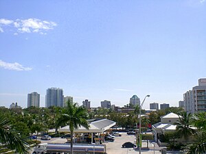
 Center Coconut Grove, as seen from the station | |||||||||||||||
| General information | |||||||||||||||
| Location | 2780 SW 27th Avenue Miami, Florida | ||||||||||||||
| Coordinates | 25°44′23″N 80°14′19″W / 25.73972°N 80.23861°W | ||||||||||||||
| Owned by | Miami-Dade County | ||||||||||||||
| Platforms | 1 island platform | ||||||||||||||
| Tracks | 2 | ||||||||||||||
| Connections | |||||||||||||||
| Construction | |||||||||||||||
| Parking | Park and ride (204 spaces) | ||||||||||||||
| Accessible | Yes | ||||||||||||||
| Other information | |||||||||||||||
| Station code | CGV | ||||||||||||||
| History | |||||||||||||||
| Opened | May 20, 1984 | ||||||||||||||
| Passengers | |||||||||||||||
| 2011 | 550,000[1] | ||||||||||||||
| Services | |||||||||||||||
| |||||||||||||||
Coconut Grove station is a station on the Metrorail rapid transit system on the western end of the Coconut Grove neighborhood of Miami, Florida. The station is located at the intersection of South Dixie Highway (US 1) and West 27th Avenue/Grapeland Boulevard (SR 9), opening to service May 20, 1984.
In 2018, there were plans to make the station entirely solar-powered.[2]
Station layout
The station has two tracks served by an island platform, with a parking lot just north of the platform.
Template:Miami Metrorail platform layout/island

