Česká Třebová
Česká Třebová | |
|---|---|
Town | |
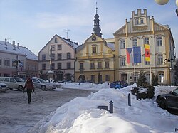
 Town hall in Česká Třebová | |
| Coordinates: 49°54′6″N 16°26′52″E / 49.90167°N 16.44778°E | |
| Country | Czech Republic |
| Region | Pardubice |
| District | Ústí nad Orlicí |
| First mentioned | 1278 |
| Government | |
| • Mayor | Magdaléna Peterková |
| Area | |
| • Total | 41.00 km2 (15.83 sq mi) |
| Elevation | 375 m (1,230 ft) |
| Population (2019-01-01[1]) | |
| • Total | 15,508 |
| • Density | 380/km2 (980/sq mi) |
| Time zone | UTC+1 (CET) |
| • Summer (DST) | UTC+2 (CEST) |
| Postal code | 560 02 |
| Website | www |


Česká Třebová (Czech pronunciation: [ˈtʃɛskaː ˈtr̝̊ɛbovaː]; German: Böhmisch Trübau) is a town in the Pardubice Region of the Czech Republic. The city is located in the east of the Czech Republic. It is the fourth most populated city and second largest in the Pardubice Region. Česká Třebová is spread over 41 km² and the population is about 15,500 citizens. The city of Česká Třebová is divided into 6 cadastral areas: Česká Třebová, Kozlov, Lhotka, Parník, Skuhrov and Svinná.
History
Česká Třebová was founded in the 13th century by king's locator lord Oldřich of Drnholec. In that time, the Roman church of St. Catherine was built. In 1304, the King of Bohemia Wenceslaus II gave it to the Zbraslav Abbey and later, in the 14th century, the town belonged to the bishops of Litomyšl. In the 15th and 16th centuries, the town prospered but due to the subsequent loss of its city rights, the Thirty Years' War, plagues and fires, it became poor and insignificant. In the 19th century, a railway station was built, which greatly aided the city development.
The city's coat of arms sports a black rooster with a human head on a red field. According to a legend, a city scribe lost the city signet and was sentenced to die as a result. Before the execution, his wife saw a rooster dug out the signet from trash, saving her husbands life.
Sports
The city is home to a 4th league Ice Hockey club, HC Kohouti Česká Třebová (cs), who play at the "Na Skále" arena with a capacity of 1,200.
Transport
Česká Třebová railway station is a major railway junction linking Prague with two pan-European corridors. The city experienced rapid development after the station was opened in 1845.
Twin towns — sister cities
Česká Třebová is twinned with:[2]
References
- ^ "Population of municipalities of the Czech republic". Czech Statistical Office. Retrieved 2019-04-30.
- ^ "Partnerská města" (in Czech). Město Česká Třebová. Retrieved 2019-08-25.
External links
 Media related to Česká Třebová at Wikimedia Commons
- Municipal website (in Czech and English)
- Information service (in Czech and English)
- Information about Czech cities (in English)
- Virtual show


