| Year | | |
|---|
| 1875 | 7,721 | — |
|---|
| 1890 | 7,716 | −0.00% |
|---|
| 1910 | 7,159 | −0.37% |
|---|
| 1925 | 7,805 | +0.58% |
|---|
| 1933 | 7,682 | −0.20% |
|---|
| 1939 | 7,799 | +0.25% |
|---|
| 1946 | 11,727 | +6.00% |
|---|
| 1950 | 11,954 | +0.48% |
|---|
| 1964 | 9,054 | −1.97% |
|---|
| 1971 | 8,969 | −0.13% |
|---|
| 1981 | 8,050 | −1.08% |
|---|
| 1985 | 7,965 | −0.27% |
|---|
| 1989 | 7,812 | −0.48% |
|---|
| 1990 | 7,661 | −1.93% |
|---|
| 1991 | 7,577 | −1.10% |
|---|
| | Year | | |
|---|
| 1992 | 7,528 | −0.65% |
|---|
| 1993 | 7,502 | −0.35% |
|---|
| 1994 | 7,531 | +0.39% |
|---|
| 1995 | 7,456 | −1.00% |
|---|
| 1996 | 7,425 | −0.42% |
|---|
| 1997 | 7,438 | +0.18% |
|---|
| 1998 | 7,477 | +0.52% |
|---|
| 1999 | 7,408 | −0.92% |
|---|
| 2000 | 7,396 | −0.16% |
|---|
| 2001 | 7,245 | −2.04% |
|---|
| 2002 | 7,174 | −0.98% |
|---|
| 2003 | 7,116 | −0.81% |
|---|
| 2004 | 7,055 | −0.86% |
|---|
| 2005 | 6,995 | −0.85% |
|---|
| 2006 | 6,912 | −1.19% |
|---|
| | Year | | |
|---|
| 2007 | 6,837 | −1.09% |
|---|
| 2008 | 6,728 | −1.59% |
|---|
| 2009 | 6,645 | −1.23% |
|---|
| 2010 | 6,497 | −2.23% |
|---|
| 2011 | 6,445 | −0.80% |
|---|
| 2012 | 6,380 | −1.01% |
|---|
| 2013 | 6,314 | −1.03% |
|---|
| 2014 | 6,429 | +1.82% |
|---|
| 2015 | 6,658 | +3.56% |
|---|
| 2016 | 6,470 | −2.82% |
|---|
| 2017 | 6,504 | +0.53% |
|---|
| 2018 | 6,556 | +0.80% |
|---|
| 2019 | 6,548 | −0.12% |
|---|
|

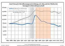 Development of Population since 1875 within the Current Boundaries (Blue Line: Population; Dotted Line: Comparison to Population Development of Brandenburg state; Grey Background: Time of Nazi rule; Red Background: Time of Communist rule)
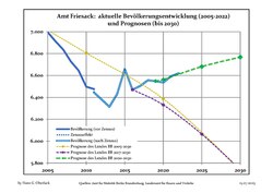 Recent Population Development and Projections (Population Development before Census 2011 (blue line); Recent Population Development according to the Census in Germany in 2011 (blue bordered line); Official projections for 2005-2030 (yellow line); for 2014-2030 (red line); for 2017-2030 (scarlet line)
