Remchingen
You can help expand this article with text translated from the corresponding article in German. (February 2009) Click [show] for important translation instructions.
|
Remchingen | |
|---|---|
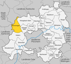
Location of Remchingen within Enzkreis district  | |
| Coordinates: 48°57′0″N 8°34′35″E / 48.95000°N 8.57639°E | |
| Country | Germany |
| State | Baden-Württemberg |
| Admin. region | Karlsruhe |
| District | Enzkreis |
| Area | |
| • Total | 24.06 km2 (9.29 sq mi) |
| Elevation | 171 m (561 ft) |
| Population (2022-12-31)[1] | |
| • Total | 11,995 |
| • Density | 500/km2 (1,300/sq mi) |
| Time zone | UTC+01:00 (CET) |
| • Summer (DST) | UTC+02:00 (CEST) |
| Postal codes | 75196 |
| Dialling codes | 07232 |
| Vehicle registration | PF |
| Website | www |
Remchingen is a municipality in the Enz district, in Baden-Württemberg, Germany, situated on the river Pfinz, 14 km southeast of Karlsruhe, and 12 km northwest of Pforzheim.
Geography
Remchingen consists of the former municipalities Nöttingen, Wilferdingen and Singen. Remchingen was originally formed on 1 January 1973 by the merging of the municipalities Wilferdingen and Singen with Nöttingen also being included on 1 January 1975.
Neighbouring municipalities are Pfinztal, Königsbach-Stein, Kämpfelbach, Keltern and Karlsbad.
Sister cities, twin towns and friendship agreements
Remchingen has sister city agreements with the following cities:
 San Biagio Platani in Italy
 Sisak, Croatia.
Approximately 300 Sanbiagesi along with their families now live in Remchingen as well as another 100 former residents of Remchingen can be found in San Biagio Platani having returned to their hometown.[2]
Economy and infrastructure
Infrastructure
Remchingen is situated on the Karlsruhe-Mühlacker railway.
The Bundestraße 10 and the Bundesautobahn 8 link the municipality to the national road network.
Education
In Remchingen you can find a Realschule (Carl-Dittler-Realschule) in Wilferdingen. Further more there is a Gymnasium and an elementary school and a Hauptschule with Werkrealschule in Singen. There are other elementary schools in Wilferdingen and Nöttingen.
Culture and sights
Remchingen is located on Bertha Benz Memorial Route which leads from Mannheim to Pforzheim.
Johann Gottfried Tulla, who got known for straightening the river Rhine, grew up in Nöttingen.
Excavations
Discoveries of remains from the Roman Empire were made in and around the church of Nöttingen, which can partly be seen in the church and in a museum in Karlsruhe.
In the development area "Niemandsberg" in Wilferdingen an archeological excavation of a Roman farm can be found, which was turned into a museum.
Sports
The football club FC Nöttingen played in the Fußball-Regionalliga in 2004, which was the third highest football league in Germany at that time. Currently they are playing in the Fußball-Oberliga Baden-Württemberg.
Other clubs in Remchingen are FC Germania Singen and FC Alemannia Wilferdingen.
Music
The Folk-Punk-Band Across the Border is from Remchingen. The musician Max Giesinger is from Remchingen too.
References
- ^ "Bevölkerung nach Nationalität und Geschlecht am 31. Dezember 2022" [Population by nationality and sex as of December 31, 2022] (CSV) (in German). Statistisches Landesamt Baden-Württemberg. June 2023.
- ^ webcontact.de. "Remchingen: Partnergemeinde". www.remchingen.de. Retrieved 2016-09-20.
External links
- Official Webpage
- Bertha Benz Memorial Route (in English)


