
Andilly, Charente-Maritime
Andilly | |
|---|---|
.JPG) The Town Hall | |
Location of Andilly  | |
 Andilly  Andilly | |
| Coordinates: 46°15′14″N 1°01′32″W / 46.2539°N 1.0256°W | |
| Country | France |
| Region | Nouvelle-Aquitaine |
| Department | Charente-Maritime |
| Arrondissement | La Rochelle |
| Canton | Marans |
| Intercommunality | Aunis Atlantique |
| Government | |
| • Mayor (2014-2020) | Sylvain Fagot |
| Area 1 | 28.53 km2 (11.02 sq mi) |
| Population (2021)[1] | 2,312 |
| • Density | 81/km2 (210/sq mi) |
| Time zone | UTC+01:00 (CET) |
| • Summer (DST) | UTC+02:00 (CEST) |
| INSEE/Postal code | 17008 /17230 |
| Elevation | 0–24 m (0–79 ft) (avg. 13 m or 43 ft) |
| 1 French Land Register data, which excludes lakes, ponds, glaciers > 1 km2 (0.386 sq mi or 247 acres) and river estuaries. | |
Andilly is a French commune in the Charente-Maritime department in the Nouvelle-Aquitaine region of southwestern France.
The inhabitants of the commune are known as Andillais or Andillaises[2]
Geography
Location
Andilly is a marshy commune in the western part of the Poitevin Marsh located in the northwest of the Charente-Maritime 6.5 km south of Marans, the chief town of the canton, and 17 km north-east of La Rochelle, the prefecture of the department.
Setting
The commune includes the town of Andilly, the village of "Sérigny", and a place called "Bel-Air".
Andilly belongs to the western or dried-up part of the Poitevin Marsh and is a large grain-producing area. The commune is polbut fgticularly well served by diversion canals, for draining and irrigation. Among these, two major canals cross the commune: the Canal du Curé crosses from east to west and the Canal from Marans to La Rochelle from north to south.
Andilly is watered in all the central parts and in the west by the Canal du Curé, which is formed from the lower reaches of the river Cure that is canalised from the commune of Anais. In Andilly, the Canal du Curé has long been called the Grand Canal of Andilly since its construction in 1771.
From north to south, the commune is traversed by the Canal from Marans to La Rochelle, which crosses the Canal du Curé northwest of Andilly town where significant crossing locks were built at a place called the Locks of Andilly.


Neighbouring communes and villages[3]
Places adjacent to Andilly, Charente-Maritime | |
|---|---|
History
- During the Wars of Religion Andilly was an advanced military post.
- There are remains of the castle
- There are ruins of a priory and a castle with underground passages
- There are also prehistoric underground refuges and relics
Administration
List of Successive Mayors[4]
| From | To | Name | Party | Position |
|---|---|---|---|---|
| 1977 | 1983 | Raoul Jardonnet | Carpenter | |
| 1983 | 1995 | Michel Fillodeau | SE | Farmer |
| 1995 | 2008 | Christian Point | SE | Civil Engineer |
| 2008 | 2014 | Maurice Debègue | SE | IT Engineer |
| 2014 | Current | Sylvain Fagot | DVG |
(Not all data is known)
Population
| Year | Pop. | ±% |
|---|---|---|
| 2004 | 1,772 | — |
| 2006 | 1,863 | +5.1% |
| 2007 | 1,900 | +2.0% |
| 2008 | 1,935 | +1.8% |
| 2009 | 1,971 | +1.9% |
| 2010 | 1,980 | +0.5% |
| 2011 | 1,999 | +1.0% |
| 2012 | 2,039 | +2.0% |
| 2013 | 2,081 | +2.1% |
| 2014 | 2,122 | +2.0% |
| 2015 | 2,163 | +1.9% |
| 2016 | 2,217 | +2.5% |
Distribution of Age Groups
.JPG)
The population of the commune is relatively young. The proportion of people over the age of 60 years (16.6%) is less than the national average (21.6%) and the departmental average (28.1%).
In contrast to the national and departmental proportions, the percentage of males in the commune is greater than that of females (51.3% against 48.4% nationally and 48.2% departmentally).
Percentage Distribution of Age Groups in Andilly and Charente-Maritime Department in 2009
| Andilly | Andilly | Charente-M | Charente-M | |
|---|---|---|---|---|
| Age Range | Men | Women | Men | Women |
| 0 to 14 Years | 23.8 | 21.9 | 17.2 | 15.1 |
| 15 to 29 Years | 15.1 | 13.9 | 16.5 | 14.4 |
| 30 to 44 Years | 23.9 | 26.1 | 18.7 | 17.9 |
| 45 to 59 Years | 21.9 | 20.6 | 21.0 | 20.8 |
| 60 to 74 Years | 11.6 | 11.3 | 17.2 | 17.8 |
| 75 to 89 Years | 3.5 | 5.7 | 9.0 | 12.4 |
| 90 Years+ | 0.2 | 0.5 | 0.5 | 1.5 |
Sources:
- Evolution and Structure of the population of the Commune in 2009, INSEE.
- Evolution and Structure of the population of the Department in 2009, INSEE.
Sites and monuments
- The Dairy and Casein Factory (19th century)
 is registered as an historical monument.[5]
 - The Church of Saint Nazaire
-
 The church of Saint-Nazaire
 -
 The church facade
 -
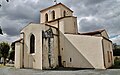 The rear of the church
.JPG)
.JPG)
.JPG)
- Remains of a medieval castle and a priory.
Transport
Railway Stations and Halts
- La Rochelle (TGV) 14.7 km
- Aytré (Halt) 16.2 km
- Angoulins (Halt) 17.6 km
- Châtelaillon 20.2 km
- Surgères (TGV) 25.4 km
Airports and Aerodromes
- La Rochelle 15.6 km
- Rochefort-Saint-Agnant 40.8 km
- Niort 48.2 km
Roads
- The D137 crosses the commune from Marans in the north passing between Andilly town and Serigny and continuing south to Usseau
- The D20 connects the D137 to Andilly town and continues south-west to Villedoux
- The D202 goes south from the town to Saint-Ouen-d'Aunis
- The D112 goes south-east from the town to Longèves
Sports
Andilly was the arrival point of the 1st stage and departure point of the 2nd stage of the Tour du Poitou-Charentes in 2004.[6]
See also
Notes and references
Notes
References
- ^ "Populations légales 2021". The National Institute of Statistics and Economic Studies. 28 December 2023.
- ^ Inhabitants of Charente-Maritime (in French)
- ^ Google Maps
- ^ List of Mayors of France
- ^ Ministry of Culture, Mérimée IA17000264 Dairy and Casein Factory (in French)

- ^ Tour Poitou-Charentes website Archived 2011-02-11 at the Wayback Machine (in French)
External links
- Andilly on the National Geographic Institute website (in French)
- Andilly on Lion1906
- Andilly on Google Maps
- Andilly on Géoportail, National Geographic Institute (IGN) website (in French)
- Andilly on the 1750 Cassini Map
- Andilly on the INSEE website (in French)
- INSEE (in French)
| International | |
|---|---|
| National | |