
Bergen, Limburg
Bergen
Baerge | |
|---|---|
 Church in Afferden | |
 Flag  Coat of arms | |
.svg) Location in Limburg | |
| Coordinates: 51°36′N 6°3′E / 51.600°N 6.050°E | |
| Country | Netherlands |
| Province | Limburg |
| Government | |
| • Body | Municipal council |
| • Mayor | Manon Pelzer (CDA) |
| Area | |
| • Total | 108.50 km2 (41.89 sq mi) |
| • Land | 103.24 km2 (39.86 sq mi) |
| • Water | 5.26 km2 (2.03 sq mi) |
| Elevation | 16 m (52 ft) |
| Population (January 2021)[4] | |
| • Total | 13,108 |
| • Density | 127/km2 (330/sq mi) |
| Time zone | UTC+1 (CET) |
| • Summer (DST) | UTC+2 (CEST) |
| Postcode | 5850–5856 |
| Area code | 0478, 0485 |
| Website | www |
Bergen () (Limburgish: Baerge) is a municipality and a town in the southeastern Netherlands.
Population centres
The town of Bergen
The town of Bergen lies about 28 km north of Venlo, close to the river Meuse. Although the municipality is named after this village, the municipal hall is located in the town of Nieuw-Bergen, the largest town in the municipality. Located near the German border, approximately 5 miles from Nieuw-Bergen, with Weeze Airport also being just a short distance away.
In 2001, Bergen had 304 inhabitants. The built-up area of the town was 0.09 km², and contained 109 residences.[5]
Topography

Gem-BergenL-OpenTopo

Notable people
- Klaas de Groot (born 1940 in Bergen) is Emeritus Professor at the University of Twente, does research and development of bioceramics
- Theo Nikkessen (born 1941 in Siebengewald) a retired Dutch amateur track cyclist, competed at the 1960 Summer Olympics
- Rob Mulders (1967 in Well – 1998) a Dutch road racing cyclist
- Lieke Martens (born 1992 in Bergen) a Dutch footballer who plays for FC Barcelona, UEFA Women's Player of the Year in 2017 and FIFA Women's Player of The Year
Gallery
-
 Nieuw-Bergen, markant torengebouw op het Raadhuisplein
 -
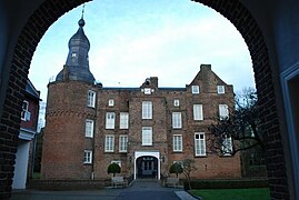 Under the arch of the Voorburcht of Kasteel Well
 -
 Nature Park, Maasduinen


.jpg)
References
- ^ "College van B&W" [Board of mayor and aldermen] (in Dutch). Gemeente Bergen. Archived from the original on 14 October 2013. Retrieved 13 October 2013.
- ^ "Kerncijfers wijken en buurten 2020" [Key figures for neighbourhoods 2020]. StatLine (in Dutch). CBS. 24 July 2020. Retrieved 19 September 2020.
- ^ "Postcodetool for 5854AX". Actueel Hoogtebestand Nederland (in Dutch). Het Waterschapshuis. Retrieved 13 October 2013.
- ^ "Bevolkingsontwikkeling; regio per maand" [Population growth; regions per month]. CBS Statline (in Dutch). CBS. 1 January 2021. Retrieved 2 January 2022.
- ^ Statistics Netherlands (CBS), Bevolkingskernen in Nederland 2001 "Archived copy". Archived from the original on 2006-03-19. Retrieved 2007-01-24.
{{cite web}}: CS1 maint: archived copy as title (link). Statistics are for the continuous built-up area.
External links
 Media related to Bergen, Limburg at Wikimedia Commons
- Official website
Places adjacent to Bergen, Limburg | |
|---|---|

| Authority control databases: Geographic |
|---|
This Dutch Limburg location article is a stub. You can help Wikipedia by expanding it. |