
Monastyryska
This article needs additional citations for verification. (July 2015) |
Monastyryska
Монастириська | |
|---|---|
 Dormition Church (former Assumption church) in Monastyryska | |
 Flag  Coat of arms | |
| Country | |
| Province | |
| District | Monastyryska Raion |
| Magdeburg rights | 1454 |
| Area | |
• Total | 14.7 km2 (5.7 sq mi) |
| Population (2001) | |
• Total | 6,344 |
| • Density | 430/km2 (1,100/sq mi) |
| Time zone | UTC+2 (EET) |
| • Summer (DST) | UTC+3 (EEST) |
Monastyryska (Template:Lang-uk; Template:Lang-pl) is a town in Ternopil Oblast, Ukraine. It is the administrative center of the Monastyryska Raion. In 2001, the population was 6,344. The town is situated on the river Koropets, 15 km (9.32 mi) from Buchach, 140 km (86.99 mi) south east from Lviv, on the road between Ternopil or Berezhany and Ivano-Frankivsk. The river Koropets forms a wide lake. Monasteryska borders Hryhoriv and Bertnyky on the east, Ozekhiv on the south, Vycholky and Stara Huta on the west, Nova Huta, Shveykiv and Kovalivka on the north.
Its older name was Monastyryshche (Монастирище),[1] which gave rise to the Yiddish name Monastrishtsh.
Prior to the war in 1939, the town had 1741 Roman Catholics (Poles), 408 Greek-Catholics (Ukrainians) and 1,310 Jews. The local Roman Catholic church has existed since 1702.
History
Crown of the Kingdom of Poland 1454–1569
Polish–Lithuanian Commonwealth 1569–1772
Habsburg Monarchy 1772–1804
Second Polish Republic ca. 1919–1945
Soviet Union 1939–1941 (occupation)
Nazi Germany 1941–1944 (occupation)
Soviet Union 1945–1991
Ukraine 1991–present
For most of its history the city belonged to the Kingdom of Poland. From the mid-14th century, to 1772 (see Partitions of Poland), it was part of Ruthenian Voivodeship. Monastyryska received a town charter in 1454, and in February 1653, a battle between Polish and Cossack troops took place here, during the Khmelnytsky Uprising. The Polish army under Stefan Czarniecki failed to capture the town, defended by Ivan Bohun.
After the partitions of Poland, Monastyryska was annexed by the Habsburg Empire. It remained in the province of Galicia until November 1918. In the Second Polish Republic, it was part of Buchach County, Tarnopol Voivodeship. Following the Soviet Invasion of Poland (September 17, 1939), the town was annexed by the Soviet Union. Many Lemkos families came to Monastyryska after Operation Vistula.
Since 1991, it has belonged to the independent Ukraine.
Roman Catholic cemetery
Monastyryska has one of the largest Roman Catholic cemeteries in the region of Podole, with more than 2,000 stone tombs. The cemetery has the burial chapel of the Potocki family as well as a military chapel, where veterans of the January Uprising and soldiers of the World War One Polish Legions rest.
Gallery
-
 Exaltation of the Holy Cross Church
 -
 Former tobacco factory
 -
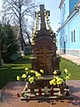 Grave of Ukrainian priests in Monastyryska
 -
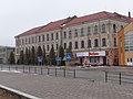
 Primary school in June 2017


People
- Norbert Rybak — Ukrainian public figure,
- Zenon Bazyli Buczkowski — Polish microbiologist and medicine professor,
- Stanisław Rossowski — Polish journalist, writer and poet,
- Horacy Safrin — Polish satirist, translator of Jewish literature,
- Alfred Suchecki — Polish criminologist, pioneer of cheiloscopy (the study of lip prints),
- Gabriel Turowski — Polish physician, immunologist and microbiologist,
- Mieczysław Zygmunt Wiśniewski — Polish soccer goalkeeper of Cracovia Krakow and Wisla Krakow, participant in the 1924 Olympic Games,
- Jan Zaleski (philologist) — Polish philologist, historian of language, Polonist and numismatist
- for centuries, the town was one of seats of the Potocki family, to which it belonged until 1844. Among famous members of the family from Monastyryska is Józef Makary Potocki, Count Antoni Potocki.
References
- ^ Рудницький С. Українські козаки, in: В. Щербак (ed.). Коли земля стогнала, Kiev: Наукова думка, 1995, ISBN 5-319-01072-9, p. 258
External links
49°05′20″N 25°10′10″E / 49.08889°N 25.16944°E
| International | |
|---|---|
| National | |