Sveti Petar u Šumi
Sveti Petar u Šumi | |
|---|---|
Municipality | |
| Sveti Petar u Šumi Municipality | |
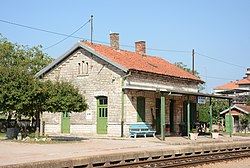
 Train station | |
| Coordinates: 45°11′N 13°52′E / 45.183°N 13.867°E | |
| Country | Croatia |
| County | Istria |
| Government | |
| • Mayor | Mario Bratulić (HDZ) |
| Population (2011)[1] | |
| • Total | 1,065 |
| Time zone | UTC+1 (CET) |
| • Summer (DST) | UTC+2 (CEST) |
| Website | www |
Sveti Petar u Šumi (English: Saint Peter in the Forest, Italian: San Pietro in Selve, archaic German: Sankt Peter im Walde) is a village and municipality (općina) in Istria County, Croatia.
Geography
It is located within the centre of the Istrian peninsula near the regional capital Pazin, about 6 km (3.7 mi) northwest of Žminj. The population is 1,065 (as of the 2011 census).
History
The settlement in the March of Istria arose around the Benedictine Saint Peter and Paul Abbey, probably founded in the 1130s and first mentioned about 1174/76. The abandoned monastery was dedicated to the Order of Saint Paul the First Hermit by the Habsburg emperor Frederick III with the consent of Pope Pius II in 1459. The present-day Baroque monastery complex was finished in 1731. The Pauline abbey was dissolved by Emperor Joseph II in 1782 but re-established in 1993.
References
- ^ "Population by Age and Sex, by Settlements, 2011 Census: Sveti Petar u Šumi". Census of Population, Households and Dwellings 2011. Zagreb: Croatian Bureau of Statistics. December 2012.
External links
- (in Croatian) Municipal site
- Central Istria Tourist Board
- (in Croatian) Pauline Abbey


