| Year | Pop. | ±% p.a. |
|---|
| 1875 | 7,349 | — |
|---|
| 1890 | 6,977 | −0.35% |
|---|
| 1910 | 7,929 | +0.64% |
|---|
| 1925 | 8,603 | +0.55% |
|---|
| 1933 | 8,245 | −0.53% |
|---|
| 1939 | 7,882 | −0.75% |
|---|
| 1946 | 11,246 | +5.21% |
|---|
| 1950 | 12,019 | +1.68% |
|---|
| 1964 | 9,254 | −1.85% |
|---|
| 1971 | 8,697 | −0.88% |
|---|
| 1981 | 7,105 | −2.00% |
|---|
| 1985 | 6,996 | −0.39% |
|---|
| 1989 | 6,738 | −0.93% |
|---|
| 1990 | 6,620 | −1.75% |
|---|
| 1991 | 6,457 | −2.46% |
|---|
| | Year | Pop. | ±% p.a. |
|---|
| 1992 | 6,341 | −1.80% |
|---|
| 1993 | 6,273 | −1.07% |
|---|
| 1994 | 6,262 | −0.18% |
|---|
| 1995 | 6,177 | −1.36% |
|---|
| 1996 | 6,144 | −0.53% |
|---|
| 1997 | 6,144 | +0.00% |
|---|
| 1998 | 6,168 | +0.39% |
|---|
| 1999 | 6,105 | −1.02% |
|---|
| 2000 | 5,997 | −1.77% |
|---|
| 2001 | 5,775 | −3.70% |
|---|
| 2002 | 5,663 | −1.94% |
|---|
| 2003 | 5,501 | −2.86% |
|---|
| 2004 | 5,388 | −2.05% |
|---|
| 2005 | 5,261 | −2.36% |
|---|
| 2006 | 5,152 | −2.07% |
|---|
| | Year | Pop. | ±% p.a. |
|---|
| 2007 | 5,089 | −1.22% |
|---|
| 2008 | 4,984 | −2.06% |
|---|
| 2009 | 4,883 | −2.03% |
|---|
| 2010 | 4,721 | −3.32% |
|---|
| 2011 | 4,667 | −1.14% |
|---|
| 2012 | 4,640 | −0.58% |
|---|
| 2013 | 4,623 | −0.37% |
|---|
| 2014 | 4,554 | −1.49% |
|---|
| 2015 | 4,505 | −1.08% |
|---|
| 2016 | 4,518 | +0.29% |
|---|
| 2017 | 4,496 | −0.49% |
|---|
| 2018 | 4,450 | −1.02% |
|---|
| 2019 | 4,429 | −0.47% |
|---|
|

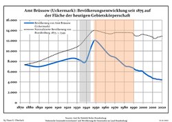 Development of population since 1875 within the current Boundaries (Blue Line: Population; Dotted Line: Comparison to Population development in Brandenburg state; Grey Background: Time of Nazi Germany; Red Background: Time of communist East Germany)
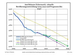 Recent Population Development and Projections (Population Development before Census 2011 (blue line); Recent Population Development according to the Census in Germany in 2011 (blue bordered line); Official projections for 2005-2030 (yellow line); for 2014-2030 (red line); for 2017-2030 (scarlet line)
