Cromer, Manitoba
Appearance
This article needs additional citations for verification. (March 2012) |
Cromer | |
|---|---|
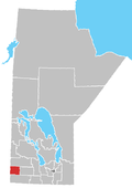
Location of Cromer in Manitoba | |
| Coordinates: 49°43′53″N 101°14′6″W / 49.73139°N 101.23500°W | |
| Country | |
| Province | |
| Region | Westman Region |
| Census Division | No. 6 |
| Government | |
| • Governing Body | Rural Municipality of Pipestone Council |
| • MP | Larry Maguire |
| • MLA | Doyle Piwniuk |
| Time zone | UTC−6 (CST) |
| • Summer (DST) | UTC−5 (CDT) |
| Postal Code | R0M 0J0 |
| Area code | 204 |
| NTS Map | 062F11 |
| GNBC Code | GAFUR |
Cromer, Manitoba is a village located in the Rural Municipality of Pipestone, in southwestern Manitoba, Canada.
In 1884 the Post Office was opened on 26-8-28W and was known as Elm Valley.[2] Its name became Cromer when the Canadian Northern Railway came through in 1907.
The community is situated near the Pipestone Creek and consists of several businesses and residences. Cromer Garage, Cromer Valley Store, Cromer Valley Construction, and Cromer Café are the main street businesses.
Notable Residents
- Mary Carter, judge [3]
See also
References
- ^ "Population and dwelling counts, for Canada and census subdivisions (municipalities), 2006 and 2001 censuses - 100% data". Statistics Canada, 2006 Census of Population. 2008-11-05. Retrieved 2009-01-30.
- ^ 1981 Trails Along the Pipestone - a history book of the Municipality of Pipestone.
- ^ Beth Bilson, Profile of Mary Carter Archived 2017-07-10 at the Wayback Machine. Encyclopedia of Saskatchewan. Retrieved 2016-11-29.
External links
- Geographic Names of Manitoba (pg. 57) - the Millennium Bureau of Canada


