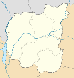
Ladan, Chernihiv Oblast
Appearance
Ladan
Ладан | |
|---|---|
Urban-type settlement | |
| Coordinates: 50°31′04″N 32°35′05″E / 50.51778°N 32.58472°E | |
| Country | Ukraine |
| Oblast | Chernihiv Oblast |
| Raion | Pryluky Raion |
| Population (2019) | |
| • Total | 5,991[1] |
| Time zone | UTC+2 (EET) |
| • Summer (DST) | UTC+3 (EEST) |
Ladan (Template:Lang-uk, Russian: Ладан) is an urban-type settlement in Pryluky Raion, Chernihiv Oblast, Ukraine. Population: Template:Ua-pop-est2019
Ladan is located on the right bank of the Uday River.
Economy
Transportation
A railway line connects Ladan with Pryluky, however, there is no passenger traffic. The closest passenger railway station is in Pryluky.
Ladan is on a local road connecting Pryluky and Sribne. At both ends it has access to H07 highway which connects Kiev and Sumy.

