Chigorodó
Appearance
Chigorodó | |
|---|---|
Municipality and town | |
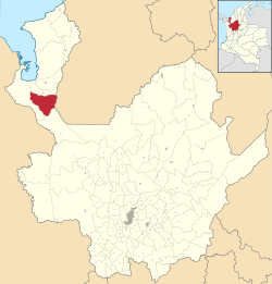
 Location of the municipality and town of Chigorodó in the Antioquia Department of Colombia | |
| Coordinates: 7°40′N 76°41′W / 7.667°N 76.683°W | |
| Country | |
| Department | |
| Subregion | Urabá |
| Founded | 1878 |
| Government | |
| • Mayor | Daniel Alvarez Sosa |
| Area | |
• Total | 608 km2 (235 sq mi) |
| Elevation | 34 m (112 ft) |
| Population (2020 est.[1]) | |
• Total | 86,239 |
| • Density | 140/km2 (370/sq mi) |
| Demonym | Chigorodoseños |
| Time zone | UTC-5 (Colombia Standard Time) |
| Area code | 57 + 4 |
| Website | Official website (in Spanish) |
Chigorodó (Spanish pronunciation: [tʃiɣoɾoˈðo]) is a town and municipality in Antioquia Department, Colombia.
Residents
- Jaime Castañeda, cyclist
References
- ^ "Resultados y proyecciones (2005-2020) del censo 2005". Retrieved 12 April 2020.
7°40′03″N 76°40′51″W / 7.66750°N 76.68083°W


