
Dahachok
Dahachok
दहचोक | |
|---|---|
Village of Chandragiri Municipality | |
 Dahachowk | |
 Dahachok Location in Nepal | |
| Coordinates: 27°42′N 85°13′E / 27.700°N 85.217°E | |
| Country | |
| Province | No. 3 |
| District | Kathmandu District |
| Population (2011) | |
| • Total | 4,036 |
| Time zone | UTC+5:45 (Nepal Time) |
Dahachok is a village and former Village Development Committee that is now part of Chandragiri Municipality in Kathmandu District in Province No. 3 of central Nepal. At the time of the 2011 Nepal census it had a population of 4,036.[1] It is located in the west of Kathmandu. It has many small units of handwork embroidery, mainly immigrant Muslim workers.[citation needed] In the date of every Bhadra Sukla Purnima (fullmoon day), this place takes the important of Indrasthan Mela.[citation needed]
Kalu Pande memorial
The burial ground on hill top of Kaji Kalu Pande is a popular hiking spot. It lies in Chandragiri, western outskirts of Kathmandu from where Gorkha can be seen.[2]
Gallery
-
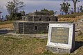 Memorial where Kalu Pande was assassinated in 1814 B.S.
 -
 Kaji Kalu Pande Statue at Samadhisthal, Dahachowk


References
- ^ "VDC Municipality.pdf" (PDF). Archived from the original (PDF) on 2013-01-24. Retrieved 2012-11-01.
- ^ "Kalu Pandey Burial Ground being popular among Kathmandu hikers". thehimalayantimes.com. 26 March 2017. Retrieved 7 March 2018.


This article about a location in Kathmandu District, Nepal is a stub. You can help Wikipedia by expanding it. |