
Uebigau-Wahrenbrück
Uebigau-Wahrenbrück | |
|---|---|
 Market square in Uebigau | |
 Coat of arms | |
Location of Uebigau-Wahrenbrück within Elbe-Elster district  | |
 Uebigau-Wahrenbrück  Uebigau-Wahrenbrück | |
| Coordinates: 51°33′N 13°21′E / 51.550°N 13.350°E | |
| Country | Germany |
| State | Brandenburg |
| District | Elbe-Elster |
| Municipal assoc. | Liebenwerda |
| Government | |
| • Mayor | Delf Gerlach |
| Area | |
| • Total | 134.91 km2 (52.09 sq mi) |
| Elevation | 84 m (276 ft) |
| Population (2022-12-31)[1] | |
| • Total | 5,159 |
| • Density | 38/km2 (99/sq mi) |
| Time zone | UTC+01:00 (CET) |
| • Summer (DST) | UTC+02:00 (CEST) |
| Postal codes | 04924, 04938 |
| Dialling codes | 035365 |
| Vehicle registration | EE, FI, LIB |
| Website | www.uebigau-wahrenbrueck.de |
Uebigau-Wahrenbrück is a town in the Elbe-Elster district, in southwestern Brandenburg, Germany. It is situated on the river Schwarze Elster, 11 km northwest of Bad Liebenwerda, and 21 km east of Torgau.
Geography
The town is composed by the villages of Bahnsdorf, Beiersdorf, Beutersitz, Bomsdorf, Bönitz, Domsdorf, Drasdo, Kauxdorf, Langennaundorf, Marxdorf, München/Elster, Neudeck, Prestewitz, Rothstein, Saxdorf, Uebigau (municipal seat), Wahrenbrück, Wiederau, Wildgrube, Winkel and Zinsdorf.
Demography
-
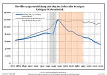 Development of Population since 1875 within the Current Boundaries (Blue Line: Population; Dotted Line: Comparison to Population Development of Brandenburg state; Grey Background: Time of Nazi rule; Red Background: Time of Communist rule)
 -
 Recent Population Development and Projections (Population Development before Census 2011 (blue line); Recent Population Development according to the Census in Germany in 2011 (blue bordered line); Official projections for 2005-2030 (yellow line); for 2014-2030 (red line); for 2017-2030 (scarlet line)


|
|
|
See also
Sons and daughters of the city

- Johann Gottlieb Graun (1702–1771), composer
- Carl Heinrich Graun (1704–1759), composer
- Gustav Seyffarth (1796–1885), Egyptologist
References
- ^ "Bevölkerungsentwicklung und Bevölkerungsstandim Land Brandenburg Dezember 2022" (PDF). Amt für Statistik Berlin-Brandenburg (in German). June 2023.
- ^ Detailed data sources are to be found in the Wikimedia Commons.Population Projection Brandenburg at Wikimedia Commons
External links
![]() Media related to Uebigau-Wahrenbrück at Wikimedia Commons
Media related to Uebigau-Wahrenbrück at Wikimedia Commons
Towns and municipalities in Elbe-Elster | ||
|---|---|---|
|  | |
| International | |
|---|---|
| National | |
| Geographic | |
This Brandenburg location article is a stub. You can help Wikipedia by expanding it. |