Carlecotes
Appearance
Carlecotes is a village in the metropolitan borough of Barnsley in South Yorkshire, England. Carlecotes is within Dunford civil parish. The village is situated at the eastern edge of the Peak District National Park, approximately 4 miles (6 km) west from Penistone, and just over 1 mile (1.6 km) north from the A628 road.
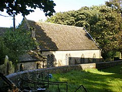
Carlecotes' church, dedicated to St Anne, is in the united benefice of Penistone and Thurlstone, and the Diocese of Sheffield. The church was completed in 1857 as a private chapel to Carlecotes Hall, and is a Grade II listed building.[1][2][3] Carlecotes Hall, which dates to the 17th century, is 15 yards (14 m) to the north of the church, and also Grade II listed.[4]
References
- ^ "St Anne, Carlecotes", The Church of England. Retrieved 5 April 2015
- ^ "History - St Anne's, Carlecotes", Team Ministry of Penistone and Thurlstone. Retrieved 5 April 2015
- ^ Historic England. "Church of St Anne (1151135)". National Heritage List for England. Retrieved 5 April 2015.
- ^ Historic England. "Carlecotes Hall (1151134)". National Heritage List for England. Retrieved 5 April 2015.
External links
 Media related to Carlecotes at Wikimedia Commons


