
Garrow, Perth and Kinross
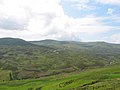
 View from just above Garrow, looking southeast to Loch Freuchie | |
 Garrow, Perth and Kinross Location within Perth and Kinross | |
| Council area | |
|---|---|
| Lieutenancy area | |
| Country | Scotland |
| Sovereign state | United Kingdom |
| Post town | Aberfeldy |
| Postcode district | PH |
| Police | Scotland |
| Fire | Scottish |
| Ambulance | Scottish |
Garrow is a clachan in the Breadalbane region of Perth and Kinross, Scotland. It is located about midway between Kenmore, 4.5 miles (7.2 kilometres) to the northwest, and Amulree, 5.3 mi (8.5 km) to the southeast. It sits below the River Quaich, which flows into nearby Loch Freuchie, itself situated between Garrow and Amulree, 2.3 mi (3.7 km) away. Garrow's elevation is about 314 metres (1,030 feet).[1]
Garrow Bridge, a single segmental arch bridge that crosses the River Quaich, is a Category C listed structure dating to the early 19th century.[2]
Garrow Hill, which rises to 730 m (2,400 ft), stands to the south of Garrow.[3]
Gallery
-
 Looking south across the River Quaich towards Garrow Hill
.jpg)
References
- ^ Garrow at PeakFinder.org
- ^ GARROW BRIDGE OVER RIVER QUAICH LB6194 - Historic Environment Scotland
- ^ Garrow Hill, Perth and Kinross - OrdnanceSurvey.co.uk
This Perth and Kinross location article is a stub. You can help Wikipedia by expanding it. |