East Point Military Reservation
| East Point Military Reservation | |
|---|---|
| Part of Harbor Defenses of Boston | |
| Nahant, Massachusetts | |
| Coordinates | 42°25′11.98″N 70°54′35.85″W / 42.4199944°N 70.9099583°W |
| Type | Coastal Defense |
| Site information | |
| Owner | Massachusetts |
| Controlled by | United States Army |
| Site history | |
| Built | 1917 |
| Built by | United States Army |
| In use | 1917–62 |
| Battles/wars | World War I World War II Cold War |
| Garrison information | |
| Garrison | Nahant, Massachusetts |
East Point Military Reservation was a World War I and World War II coastal defense site located in Nahant, Massachusetts. In 1955–62 it was a Nike missile launch site.[1] As of 2016 most of the site is the Marine Science Center of Northeastern University.[2]
History
The East Point Military Reservation was originally acquired by the US Army from the Lodge family in 1917. It originally consisted of a searchlight and an observation post.[1] The site was planned to be named Fort Henry Cabot Lodge for the prominent senator on whose land part of the facility was built, but this was never acted upon.
The site today
The site today consists of towers, the foundations of buildings, and bunkers formerly for guns and ammunition.
East Point Batteries

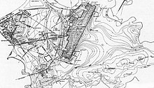
The East Point Batteries, located in Nahant, Massachusetts, were part of the Harbor Defenses of Boston during World War II. Three separate gun batteries were built: Battery Murphy (two 16-inch guns), Battery 206 (two 6-inch guns), and a temporary 2-gun battery of 155 mm artillery.[1][3] Along with these guns were three related fire control towers: two on Swallow Cave Rd. and one on Nahant Rd., plus a large underground plotting room behind Battery Murphy that served that battery's two big guns. In addition, to the north were fire control towers at 291 Ocean Avenue in Marblehead and Smiths Point in Manchester. Also, the northern series of Navy-operated magnetic loop cables, emplaced to detect enemy vessels (particularly U-boats) approaching Boston Harbor, terminated on the shore just southeast of the two 155mm gun positions. This was indicator loop Station 1D.[4][5] All of these facilities were located in the area called East Point, at the extreme southeast end of the Nahant tombolo, as shown in the map at right. After 1943, these guns, together with the two 12-inch guns of Battery Gardner at Fort Ruckman, made Nahant the most heavily armed portion of Boston's coast defenses.
The Guns
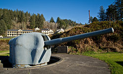
Battery Murphy was one of a series of 16-inch gun emplacements that were installed near U.S. harbors before and during World War II. Construction on this battery commenced on 23 January 1942 and was completed just under two years later, on 18 December 1943. The guns were 16-inch Navy MkIIMI guns on M4 barbette carriages with a range of 45,150 yards (41,290 m).[6] The guns were housed in casemates, part of a large bunker for magazines and fire control equipment.[1]
Battery 206 was a 6-inch gun battery of a type designed to complement the World War II 16-inch batteries. The battery was built in 1942–43, concurrently with Battery Murphy. It consisted of two 6-inch M1903 guns on long-range shielded barbette carriages, with a range of 27,100 yards (24,800 m).[7] A large bunker between the guns housed magazines and fire control equipment.[1]
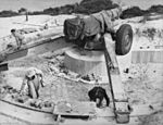
The battery of two 155mm guns was made up of 155 mm M1918 towed guns emplaced on so-called "Panama mounts", 10-foot diameter concrete pads surrounded by circular steel rails 40 feet in diameter that carried the trails of the guns.[1]


This battery was a stopgap measure, put in place quickly between March and May 1942, as an emergency defense against enemy ships and submarines while the batteries of larger guns and their related fire control towers were being built.[8] From the extreme southeast end of East Point, these guns, with their 12-mile maximum range, could command the entire ocean front of Boston Harbor and could reach all the way south to Hingham, MA.
The guns, which could be fired rapidly, were mounted roughly 250 feet apart, and a small, wooden Battery Commander's station, containing a depression position finder and a coincidence range finder was built between them. (See the image gallery below for plans and dimensions of this battery.) This 155mm gun battery is believed to have been the only one of its type in the Boston Harbor defenses, and the surviving platform of Gun 1 is thought to be relatively rare in New England.
Fire Control Structures

In addition to having one of the largest concentrations of coast artillery in New England, East Point featured the largest concentration of fire control towers, used to direct and correct the fire of these guns.
Postwar use
In 1948 the guns were removed and the site ceased to be a coast defense installation. In 1952–56 a four-gun 90 mm anti-aircraft battery was at the site. In 1955–62 the site was Nike missile site B-17L or B-17C. Northeastern University acquired the property in 1967.[1][9]
Gallery of Additional Images
 |
 |
 |
 |
See also
- 9th Coast Artillery (United States)
- 241st Coast Artillery (United States)
- Seacoast defense in the United States
- United States Army Coast Artillery Corps
- List of military installations in Massachusetts
References
- ^ a b c d e f g East Point Military Reservation at FortWiki.com
- ^ Northeastern University Marine Science Center official website
- ^ Berhow, pp. 205-206
- ^ Indicator Loop Stations at Indicatorloops.com
- ^ East Point indicator loops at Indicatorloops.com
- ^ Berhow, p. 61
- ^ Berhow, p. 61
- ^ This gun was extensively used in World War I as the Canon de 155 mm Grande Puissance Filloux (GPF), designed for the French Army, but also used and manufactured by the United States for the U.S. Army and Marine Corps under the designations of M1917 (French-built) and M1918 (US-built). With the American forces, some were mounted on M12 Gun Motor Carriages; the GPF was the standard heavy artillery gun until 1942 when the 155 mm M1A1 "Long Tom" field guns replaced them. See the World War II Database.
- ^ "Boston Harbor II - Harbor Defenses of Boston". American Forts Network. Retrieved 18 July 2020.
- Berhow, Mark A., Ed. (2015). American Seacoast Defenses, A Reference Guide, Third Edition. McLean, Virginia: CDSG Press. ISBN 978-0-9748167-3-9.
{{cite book}}: CS1 maint: multiple names: authors list (link) - Lewis, Emanuel Raymond (1979). Seacoast Fortifications of the United States. Annapolis: Leeward Publications. ISBN 978-0-929521-11-4.
External links
- List of all US coastal forts and batteries at the Coast Defense Study Group, Inc. website


