Red Line (DART)
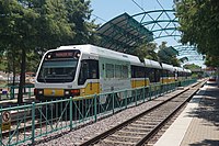
 Northbound Red Line train at Galatyn Park Station | |
| Overview | |
| Status | Operational |
| Owner | DART |
| Locale | Dallas, Texas |
| Termini |
|
| Stations | 25 |
| Service | |
| Type | Light rail |
| System | DART Light Rail |
| Operator(s) | DART |
| History | |
| Opened | June 14, 1996 |
| Technical | |
| Line length | 27.7 mi (44.6 km) |
| Track gauge | 4 ft 8+1⁄2 in (1,435 mm) |
| Electrification | overhead catenary |
| Highest elevation | at grade, elevated, underground |
Red Line | |||||||||||||||||||||||||||||||||||||||||||||||||||||||||||||||||||||||||||||||||||||||||||||||||||||||||||||||||||||||||||||||||||||||||||||||||||||||||||||||||||||||||||||||||||||||||||||||||||||||||||||||||||||||||||||||||||||||||||||||||||||||||||||||||||||||||||||||||||||||||||||||||||||
|---|---|---|---|---|---|---|---|---|---|---|---|---|---|---|---|---|---|---|---|---|---|---|---|---|---|---|---|---|---|---|---|---|---|---|---|---|---|---|---|---|---|---|---|---|---|---|---|---|---|---|---|---|---|---|---|---|---|---|---|---|---|---|---|---|---|---|---|---|---|---|---|---|---|---|---|---|---|---|---|---|---|---|---|---|---|---|---|---|---|---|---|---|---|---|---|---|---|---|---|---|---|---|---|---|---|---|---|---|---|---|---|---|---|---|---|---|---|---|---|---|---|---|---|---|---|---|---|---|---|---|---|---|---|---|---|---|---|---|---|---|---|---|---|---|---|---|---|---|---|---|---|---|---|---|---|---|---|---|---|---|---|---|---|---|---|---|---|---|---|---|---|---|---|---|---|---|---|---|---|---|---|---|---|---|---|---|---|---|---|---|---|---|---|---|---|---|---|---|---|---|---|---|---|---|---|---|---|---|---|---|---|---|---|---|---|---|---|---|---|---|---|---|---|---|---|---|---|---|---|---|---|---|---|---|---|---|---|---|---|---|---|---|---|---|---|---|---|---|---|---|---|---|---|---|---|---|---|---|---|---|---|---|---|---|---|---|---|---|---|---|---|---|---|---|---|---|---|---|---|---|---|---|---|---|---|---|---|---|---|---|---|---|---|
| |||||||||||||||||||||||||||||||||||||||||||||||||||||||||||||||||||||||||||||||||||||||||||||||||||||||||||||||||||||||||||||||||||||||||||||||||||||||||||||||||||||||||||||||||||||||||||||||||||||||||||||||||||||||||||||||||||||||||||||||||||||||||||||||||||||||||||||||||||||||||||||||||||||
| |||||||||||||||||||||||||||||||||||||||||||||||||||||||||||||||||||||||||||||||||||||||||||||||||||||||||||||||||||||||||||||||||||||||||||||||||||||||||||||||||||||||||||||||||||||||||||||||||||||||||||||||||||||||||||||||||||||||||||||||||||||||||||||||||||||||||||||||||||||||||||||||||||||
The Red Line is a light rail line in Dallas, Texas operated by the Dallas Area Rapid Transit system. It began operations in June 1996, and is one of two inaugural light rail lines in the DART Light Rail system alongside the Blue Line.
Route
Westmoreland to Downtown
The southwestern terminus of the Red Line is at Westmoreland Station in southwest Dallas at the intersection of Illinois Avenue and Westmoreland Road. The southwestern part of the Red Line runs on a private right-of-way with grade crossings. Just before 8th & Corinth, the line merges with the Blue Line. The joint Red and Blue Line tracks then rise on to a viaduct that crosses Cedar Creek, the Trinity River, and a freight railroad line. At Lamar Street, the line turns north at a wye where a pair of tracks leading to one of two train yards on the system diverges. The Red and Blue Lines continue north, crossing the Landry Freeway, travelling under the Dallas Convention Center and stop at Dallas Union Station. After crossing over Main Street, the lines turn east as they merge with the Green Line and Orange Line and enter downtown Dallas. At this point, the lines leave their right of ways and operate on a dedicated street-running right of way.
Downtown to Parker Road
The four DART lines share a common section of track through downtown, with four stops: West End, Akard Street, St. Paul Street and Pearl Street.
After Pearl Street, street running ends and the lines return to private right-of-ways. The four lines diverge at a wye, with the Green Line diverging to the southeast while the Red, Blue and Orange Lines turn north, cross the Good-Latimer Expressway at grade, and descend into a long tunnel under the Central Expressway (US 75), with a stop at Cityplace. The lines exit the tunnel at Mockingbird. The Blue Line diverges from the Red Line and heads east, while the Red and Orange Lines turn north.
The Red Line then travels through north Dallas, Richardson and Plano. Most of the line runs at grade level with grade crossings, although portions of the route run on elevated viaducts. The line terminates at the Parker Road Station at Park Boulevard near Central Expressway in Collin County.
History
The Red Line was part of the initial launch of DART's light rail testing and service in 1996. At the time, the line only ran from Westmoreland Station to Pearl Station in the northeast corner of downtown. In 1997, the Red Line was extended to Park Lane Station, and was the first DART line to use the 3.5-mile twin tunnels. On December 18, 2000, Cityplace Station, the southwest's first commercial subway station was opened along the Red Line underneath Cityplace Tower in the tunnel under the Central Expressway.
In 2002, the Red Line extended into Richardson, ending at Galatyn Park Station, extending the light rail service 9 miles (14.5 km) over its original length. Later that year, the line was opened to the Parker Road Station, an additional 3 miles (4.8 km) of track, its current terminus. Much of the route was constructed on the former Texas Electric Railway route.
Stations
Daily Service
- Listed from north to south
| Station | Other lines | Opened | Notes |
|---|---|---|---|
| Parker Road | 2002 | Terminus for Red and Orange Lines (Orange Line During peak-hour only) | |
| Downtown Plano | 2002 | ||
| CityLine/Bush | 2002 | Formerly Bush Turnpike Station until March 14, 2016. Planned Silver Line transfer station | |
| Galatyn Park | 2002 | ||
| Arapaho Center | 2002 | ||
| Spring Valley | 2002 | ||
| LBJ/Central | 2002 | Terminus for Orange Line outside peak hours | |
| Forest Lane | 2002 | ||
| Walnut Hill | 2002 | ||
| Park Lane | 1997 (extended 2002) | ||
| Lovers Lane | 1997 | ||
| SMU/Mockingbird | 1997 | Northernmost transfer for the Blue Line | |
| Cityplace/Uptown | 2000 | Transfer to | |
| Pearl/Arts District | 1996 | Easternmost transfer for Green Line | |
| St. Paul | 1996 | Transfer to | |
| Akard | 1996 | ||
| West End | 1996 | Westernmost transfer station for the Orange Line and Green Line | |
| EBJ Union Station | 1996 | Transfer to | |
| Convention Center | 1996 | ||
| Cedars | 1996 | ||
| 8th & Corinth | 1996 | Southernmost transfer for the Blue Line | |
| Dallas Zoo | 1996 | ||
| Tyler/Vernon | 1996 | ||
| Hampton | 1996 | ||
| Westmoreland | 1996 |
Special Event Service
- Deep Ellum Station (Served regularly by Green Line)
- Baylor University Medical Center Station (Served regularly by Green Line)
- Fair Park Station (Served regularly by Green Line)
- Victory Station (Also served by Green Line, Orange Line)


