
Jouars-Pontchartrain
Jouars-Pontchartrain | |
|---|---|
 Castle of Pontchartrain | |
.svg) Coat of arms | |
Location of Jouars-Pontchartrain  | |
 Jouars-Pontchartrain  Jouars-Pontchartrain | |
| Coordinates: 48°48′14″N 1°54′08″E / 48.8039°N 1.9022°E | |
| Country | France |
| Region | Île-de-France |
| Department | Yvelines |
| Arrondissement | Rambouillet |
| Canton | Aubergenville |
| Intercommunality | Cœur d'Yvelines |
| Government | |
| • Mayor (2020–2026) | Philippe Emmanuel |
| Area 1 | 9.65 km2 (3.73 sq mi) |
| Population (2021)[1] | 5,814 |
| • Density | 600/km2 (1,600/sq mi) |
| Time zone | UTC+01:00 (CET) |
| • Summer (DST) | UTC+02:00 (CEST) |
| INSEE/Postal code | 78321 /78760 |
| Elevation | 67–171 m (220–561 ft) (avg. 112 m or 367 ft) |
| 1 French Land Register data, which excludes lakes, ponds, glaciers > 1 km2 (0.386 sq mi or 247 acres) and river estuaries. | |
Jouars-Pontchartrain is a commune in the Yvelines department in the Île-de-France region in north-central France. It is approximately 35 kilometres from Paris. This city is famous for the Château de Pontchartrain.
Monuments
- The Château de Pontchartrain built in the 17th century. It was held for many years by the family Phélypeaux.
- St Martin's Church from the 12th century.
- St-Lin's church from the beginning of the 20th century.
-
 Entrance of St Martin's Church .
 -
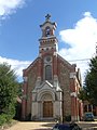 St-Lin's church.


Twin towns
See also
References
- ^ "Populations légales 2021". The National Institute of Statistics and Economic Studies. 28 December 2023.
Wikimedia Commons has media related to Jouars-Pontchartrain.
This Yvelines geographical article is a stub. You can help Wikipedia by expanding it. |