Seacombe railway station
53°24′36″N 3°01′10″W / 53.4099°N 3.0194°W
Seacombe | |
|---|---|
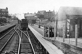
 The station in 1959 | |
| General information | |
| Location | Wallasey, Wirral England |
| Grid reference | SJ323908 |
| Platforms | 3 |
| Other information | |
| Status | Disused |
| History | |
| Original company | Wirral Railway |
| Post-grouping | LMS |
| Key dates | |
| 1 June 1895 | opened |
| 4 January 1960 | passenger service withdrawn |
| 16 June 1963 | closed completely |
Seacombe railway station was located in Wallasey, Wirral, England.[1][2] The station was opened by the Wirral Railway in 1895 and closed in 1963.
History
The station was the terminus of a small branch line that ran from Seacombe Junction to opposite the ferry terminal at Seacombe, adjacent to the River Mersey.[3] It was opened on 1 June 1895 as part of the Wirral Railway, with only one other station (Liscard and Poulton) on the stretch of line. The station's single platform was largely of timber construction with a small wooden waiting shelter near the exit. An additional platform was on the site,[4] but was never used as the adjacent line was for the turning round of steam locomotives. The station buildings were constructed of corrugated iron. This was intended as a temporary measure, pending the building of a more permanent station adjoining the ferry terminal.[5]
On 1 July 1901 Seacombe became Seacombe & Egremont, then reverted to its original name on 5 January 1953. The station saw regular passenger trips to Birkenhead, New Brighton and Chester with occasional specials to Wrexham and West Kirby. However, the line was more focused on goods rather than passengers, so when the majority of the Wirral Railway was electrified in 1938 the Seacombe branch was omitted. Passenger services ended on 4 January 1960,[6] although goods services continued for three further years until the station closed completely on 16 June 1963.[5][7]
Since closure
The cutting in which the line was situated is now the approach road to the Kingsway (Wallasey) Tunnel. Traces of the immediate approach to the station can be found at the rear of the supermarket car park in Church Road in the form of bridge stonework and a small section of sandstone wall at the roundabout facing the Seacombe Ferry Terminal.[7]
References
- ^ The station on a navigable Edwardian 6" OS map with overlays, via National Library of Scotland
- ^ The station on a navigable map with overlays, via Rail Map Online
- ^ Mitchell & Smith 2013, map XXXVI
- ^ Aves 2011, p. 330.
- ^ a b Merseyside Railway History Group 1994, pp. 50–51
- ^ Mitchell & Smith 2013, fig. 108
- ^ a b "Disused Stations: Seacombe". Subterranea Britannica. Retrieved 22 May 2008.
Sources
- Aves, Bill (May 2011). Smith, Martin (ed.). "Unsung heroes - N4 and N5 0-6-2Ts (Part Two)". Railway Bylines. 16 (6). Radstock: Irwell Press Limited. ISSN 1360-2098. OCLC 163283819.
{{cite journal}}: Invalid|ref=harv(help) - Merseyside Railway History Group (1994). Railway Stations of Wirral. Ian & Marilyn Boumphrey. pp. 50–51. ISBN 1-899241-02-7.
{{cite book}}: Invalid|ref=harv(help) - Mitchell, Vic; Smith, Keith (2013). Wrexham to New Brighton. West Sussex: Middleton Press. ISBN 9781908174475. OCLC 859543196.
{{cite book}}: Invalid|ref=harv(help)
| Preceding station | Disused railways | Following station | ||
|---|---|---|---|---|
| Terminus | London, Midland and Scottish Railway Wirral Railway |
Liscard and Poulton Line and station closed |


