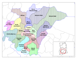
Amansie West District
Amansie West District | |
|---|---|
 Districts of Ashanti | |
| Coordinates: 6°28′N 1°53′W / 6.467°N 1.883°W | |
| Country | |
| Region | Ashanti Region |
| Capital | Manso Nkwanta |
| Government | |
| • District Executive | Ben Kwakye-Adeefe |
| Area | |
• Total | 1,141 km2 (441 sq mi) |
| Population (2012) | |
• Total | — |
| Time zone | UTC+0 (GMT) |
Amansie West District is one of the forty-three districts in Ashanti Region, Ghana.[1][2] Originally created as an ordinary district assembly in 1988, after it was split from the former Amansie District. On 15 March 2018, part of the district was split off to create Amansie South District. The district assembly is located in the southern part of Ashanti Region and has Manso Nkwanta as its capital town.
It covers an area of 1,364 square kilometers and has a population of 144,104 according to the 2010 census. Aside from its capital, the main settlements in the district include Mpatuam, Pakyi No. 1, Antoakrom and Esuowin.[3]
There are 4 main ethnic groups in the district: the largest group of people is the Akans (86.4%), with three other smaller groups the Northerners (9.7%), the Ewe (3.6%) and the Ga (1.1%). They are also predominantly Christians (79.4%), with some Muslims (8%), and smaller number belonging to other sects or indigenous beliefs.[3]
References
- ^ "Ashanti Region". GhanaDistricts.com. Archived from the original on 8 February 2006.
- ^ "Amansie West District". GhanaDistricts.com.
- ^ a b "Amansie West". Ministry of Food and Agriculture, Republic of Ghana.
- "Districts of Ghana". Statoids.
6°28′N 1°53′W / 6.467°N 1.883°W


