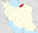
Aliabad-e Katul
Aliabad-e Katul
molla shahiعلی آباد كتول | |
|---|---|
City | |
 Aliabad-e Katul | |
| Coordinates: 36°54′30″N 54°52′08″E / 36.90833°N 54.86889°E | |
| Province | Golestan |
| County | Aliabad |
| Bakhsh | Central |
| Population (2016 Census) | |
| • Total | 52,838 [1] |
| Time zone | UTC+3:30 (IRST) |
| • Summer (DST) | UTC+4:30 (IDST) |
| Aliabad-e Katul at GEOnet Names Server | |
Aliabad-e Katul (Persian: علی آباد كتول, also Romanized as ‘Alīābād-e Katūl, Aliabad-e Katool, and Aliâbâd Katool; also known simply as Aliabad (Persian: علی آباد, also Romanized as ‘Alīābād)[2] is a city and capital of Aliabad County, in Golestan Province, Iran. At the 2006 census its population was 46,183, in 11,676 families.[3]
The city is sited on a hillside of the Alborz Mountains between Gorgan and Azad Shahr. The Kaboud-val waterfall is near the city. Nearby are the villages of Kholin Darreh, Chinou, Alestan, and Mayan.
References
- ^ https://www.amar.org.ir/english
- ^ Aliabad-e Katul can be found at GEOnet Names Server, at this link, by opening the Advanced Search box, entering "-3052543" in the "Unique Feature Id" form, and clicking on "Search Database".
- ^ "Census of the Islamic Republic of Iran, 1385 (2006)" (Excel). Statistical Center of Iran. Archived from the original on 2011-09-20.
Wikimedia Commons has media related to Aliabad-e Katul.


