Desembarco del Granma National Park
| Desembarco del Granma National Park | |
|---|---|
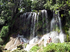
 A waterfall in the national park | |
| Location | Cuba |
| Nearest city | Niquero |
| Coordinates | 19°53′00″N 77°38′00″W / 19.88333°N 77.63333°W |
| Area | 261.80 km² |
| Established | 1986 |
| Type | Natural |
| Criteria | vii, viii |
| Designated | 1999 (23rd session) |
| Reference no. | 889 |
| State Party | Cuba |
| Region | Latin America and the Caribbean |
Desembarco del Granma National Park (Spanish: Parque Nacional Desembarco del Granma) is a national park in south-eastern Cuba, in what is now Granma Province. The name of the park means "Landing of the Granma" and refers to the yacht in which Fidel Castro, Che Guevara, Raúl Castro, and 79 of their supporters sailed from Mexico to Cuba in 1956 and incited the Cuban Revolution.
It was listed by UNESCO as a World Heritage Site because of its uplifted marine terraces and pristine sea cliffs.
See also
- Niquero, the municipality in which the national park is located.
- Granma, the revolutionaries' yacht that landed here.
References
External links
![]() Media related to Desembarco del Granma National Park at Wikimedia Commons
Media related to Desembarco del Granma National Park at Wikimedia Commons

