
Vernon, Eure
Vernon | |
|---|---|
 Old mill on the broken bridge | |
.svg) Coat of arms | |
Location of Vernon  | |
 Vernon  Vernon | |
| Coordinates: 49°05′N 1°29′E / 49.09°N 1.49°E | |
| Country | France |
| Region | Normandy |
| Department | Eure |
| Arrondissement | Les Andelys |
| Canton | Vernon |
| Intercommunality | Portes de l'Eure |
| Government | |
| • Mayor (2015 –) | François Ouzilleau |
| Area 1 | 34.92 km2 (13.48 sq mi) |
| Population (2021)[1] | 24,543 |
| • Density | 700/km2 (1,800/sq mi) |
| Time zone | UTC+01:00 (CET) |
| • Summer (DST) | UTC+02:00 (CEST) |
| INSEE/Postal code | 27681 /27200 |
| Elevation | 10–148 m (33–486 ft) |
| 1 French Land Register data, which excludes lakes, ponds, glaciers > 1 km2 (0.386 sq mi or 247 acres) and river estuaries. | |
Vernon (pronounced [vɛʁnɔ̃]) is a commune in the department of Eure in the Normandy region in northern France.
It lies on the banks of the Seine River, about midway between Paris and Rouen. The city is known for its production of engines by the SNECMA group.
History
Mentioned in a Latin written document as Vernum, the /m/ at the end could be the last remains of the Celtic magus 'plain' or 'market', or it is a simple latinization, and the origin is just the Celtic word *uerno, alder tree (Breton gwern, Welsh gwern, Irish fern, modern French verne).
The village gave its name to a family who took part in the Norman Conquest of England, and then became a British first name.
Important dates
- 750 - First mention of name Vernon by Pepin the Short.
- 1070 - Birth of Saint Adjutor.
- 1153 - Vernon is besieged by king Louis VII.
- 1196 - Vernon is joined to the royal domain by King Philip II Augustus.
- 1204 - Building of Vernon Castle
- 1227 - Saint-Louis comes to Vernon.
- 1415 - Vernon becomes English.
- 1449 - Vernon passes to France (king Charles VII).
- 1596 - 8 October, Henry IV visits Bizy Castle.
- 1600 - Construction of the Vieux-Moulin (old mill).
- 1606 - Henry IV creates a school.
- 1723 - Creation of the Avenue des Capucins.
- 1789 - Thomas Jefferson, his family, and Sally and James Hemings stop at Vernon on their way to Le Havre to return to America.
- 1804 - Vernonnet is attached to Vernon.
- 1810 - Napoleon I comes to Vernon.
- 1843 - Arrival of the Paris-Rouen-Le Havre railroad.
- 1858 - Building of the Saint-Louis Hospital.
- 1860 - Highworks urbanism in the center by Suchet d'Albuféra.
- 1862 - Building of the library.
- 1895 - Inauguration of the new city hall by Adolphe Barette.
- 1897 - First cinema show at the Vernon Theatre.
- 1910 - The Seine river floods the city.
- 1946 - Arrival of 28 German scientists from Peenemünde to develop French rockets.
- 1951 - First attempt to launch a Véronique rocket (Vernonelectronic) [1]
- 1955 - Inauguration of the Clémenceau Bridge.
- 1966 - Building of the Georges Dumézil high school .
- 1983 - First edition of the Foire aux Cerises (cherry fair).
- 1988 - 18 October, visit from François Mitterrand.
- 1992 - Building of the Espace Culturel Philippe Auguste.
- 1996 - 30 June, visit from Hillary Clinton.
- 2004 - 16 January, visit from Jean-Louis Borloo.
- 2004 - 29 January, visit from Alain Lambert.
- 2006 - 26 January, visit from Nicolas Sarkozy
- 2007 - 18 September, visit from Sharon Stone.
- 2007 - 19 September, visit from Emperor of Japan Akihito.
- 2008 - 15 June, visit from Laura Bush.
- 2009 - 16 March, visit from Bruno Le Maire.
- 2010 - August, produce film Maupassant with Cristiana Reali and Patrick Chesnais in historic city.
- 2010 - 6 August, visit from Woody Allen, Rachel McAdams, Owen Wilson, and Adrien Brody for production of Midnight in Paris in Giverny.
- 2010 - 14 December, Nicolas Sarkozy, Bruno Le Maire, Valérie Pécresse, Eric Besson, and Louis Gallois visit Snecma
International relations
Twin towns – Sister cities
Vernon is twinned with:
Personalities
- Tongo Hamed Doumbia, footballer
- Chantal Jouanno (born July 12, 1969), politician, former Secretary of State for Ecology.
- Jared Khasa, footballer
- Joseph Mallord William Turner (April 23, 1775 − December 19, 1851), Romantic landscape painter.
- Jeremy Thiry-Césaire (born October 5, 1980), politician, relative of the writer, poet and politician Aimé Césaire.
- Ousmane Dembélé, footballer
- Philippe Montanier, football manager
Population
| Year | Pop. | ±% |
|---|---|---|
| 1793 | 4,029 | — |
| 1800 | 5,202 | +29.1% |
| 1806 | 4,793 | −7.9% |
| 1821 | 4,812 | +0.4% |
| 1831 | 4,888 | +1.6% |
| 1836 | 5,301 | +8.4% |
| 1841 | 6,128 | +15.6% |
| 1846 | 5,204 | −15.1% |
| 1851 | 6,463 | +24.2% |
| 1856 | 7,674 | +18.7% |
| 1861 | 7,410 | −3.4% |
| 1866 | 7,787 | +5.1% |
| 1872 | 7,961 | +2.2% |
| 1876 | 7,636 | −4.1% |
| 1881 | 7,881 | +3.2% |
| 1886 | 8,164 | +3.6% |
| 1891 | 8,288 | +1.5% |
| 1896 | 8,492 | +2.5% |
| 1901 | 8,757 | +3.1% |
| 1906 | 8,667 | −1.0% |
| 1911 | 8,733 | +0.8% |
| 1921 | 8,814 | +0.9% |
| 1926 | 9,725 | +10.3% |
| 1931 | 10,621 | +9.2% |
| 1936 | 11,330 | +6.7% |
| 1946 | 11,242 | −0.8% |
| 1954 | 14,460 | +28.6% |
| 1962 | 17,247 | +19.3% |
| 1968 | 18,872 | +9.4% |
| 1975 | 22,422 | +18.8% |
| 1982 | 22,243 | −0.8% |
| 1990 | 23,659 | +6.4% |
| 1999 | 24,063 | +1.7% |
| 2008 | 24,998 | +3.9% |
Gallery
-
 Collégiale Notre-Dame (now Parish Church)
 -
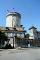 Tour des archives (Philippe Auguste's Keep)
 -
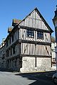
 Maison du Temps Jadis (Medieval House)
 -
 Corner of Rue du Pont and Rue Carnot
 -
 Museum
 -
 Place Barette
 -
 Hôtel de ville (Town Hall)
 -
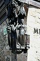
 Tomb of Saint-Mauxe
 -
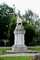 War memorial
 -
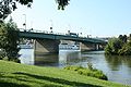 Pont Clemenceau
 -
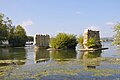 Medieval bridge
 -
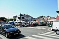 Place Charles de Gaulle's Market Day
 -
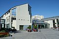 Espace Philippe-Auguste Culture Centre


See also
References
- ^ "Populations légales 2021". The National Institute of Statistics and Economic Studies. 28 December 2023.
External links
Wikimedia Commons has media related to Vernon (Eure).
- Vernon Vernon Web (In French)
- The town that liberated itself in 1944 Vernon, the town that liberated itself, in 1944 (a tale of the Resistance)
- Vernon - Official tourist board website in English
- Official website (in French)
- Vernon Unofficial website (in English and French)
- Vernon News Vernon Section of Giverny News (In French)
| National | |
|---|---|
| Geographic | |
| Other | |