Al-Busi
| Bu`si Sheikdom مشيخة البعسي | |||||||||
|---|---|---|---|---|---|---|---|---|---|
| State of the Protectorate of South Arabia | |||||||||
| 18th century–1967 | |||||||||
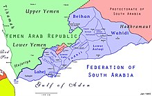
 Map of the Federation of South Arabia | |||||||||
| • Type | Sheikhdom | ||||||||
| Historical era | 20th century | ||||||||
• Established | 18th century | ||||||||
• Disestablished | 1967 | ||||||||
| |||||||||
Al-Bu`si, Busi (Arabic: البعسي Bu`sī), or the Bu`si Sheikhdom (Arabic: مشيخة البعسي Mashyakhat al-Bu`sī), was a small state in the British Aden Protectorate. Its last sheikh was deposed in 1967 upon the founding of the People's Republic of South Yemen and the area is now part of the Republic of Yemen.[1]
History
Al-Bu`si is one of the most obscure of the five sheikhdoms of Upper Yafa. Located in a mountainous area it was part nominally of the Western Aden Protectorate, although no treaty is known. The Al-Bu`si Sheikhdom did not join the Federation of South Arabia, but was nominally part of the Protectorate of South Arabia.[2] The Sheikh of Bu`si has been recorded as one of the rulers of South Arabian states under British protection attending the second Lahej conference in 1930.[3]
See also
References
- ^ Paul Dresch. A History of Modern Yemen. Cambridge, UK: Cambridge University Press, 2000
- ^ R.J. Gavin. Aden Under British Rule: 1839-1967. London: C. Hurst & Company, 1975
- ^ Journal of The Royal Central Asian Society, Volume 18, Issue 2, 1931. Page 299
