
Apchon
Apchon | |
|---|---|
 A general view of Apchon, seen from the château | |
 Coat of arms | |
Location of Apchon  | |
 Apchon  Apchon | |
| Coordinates: 45°15′00″N 2°41′41″E / 45.25°N 2.6947°E | |
| Country | France |
| Region | Auvergne-Rhône-Alpes |
| Department | Cantal |
| Arrondissement | Mauriac |
| Canton | Riom-ès-Montagnes |
| Intercommunality | Pays de Gentiane |
| Government | |
| • Mayor (2008–2020) | Pierre Pouget |
| Area 1 | 12.43 km2 (4.80 sq mi) |
| Population (2009) | 210 |
| • Density | 17/km2 (44/sq mi) |
| Time zone | UTC+01:00 (CET) |
| • Summer (DST) | UTC+02:00 (CEST) |
| INSEE/Postal code | 15009 /15400 |
| Elevation | 833–1,143 m (2,733–3,750 ft) (avg. 1,060 m or 3,480 ft) |
| 1 French Land Register data, which excludes lakes, ponds, glaciers > 1 km2 (0.386 sq mi or 247 acres) and river estuaries. | |
Apchon is a commune in the Cantal department in the Auvergne region of south-central France.
The inhabitants of the commune are known as Apchonnais or Apchonnaises.[1]
Geography
Apchon is located some 80 km south-west of Clermont-Ferrand, 25 km north-west of Murat, and 30 km south-east of Bort-les-Orgues. Access is by the D3 road from Riom-ès-Montagnes in the north-west passing through the north of the commune to Murat in the south-east. Access to the village is by the D49 which branches off the D3 north-east of the commune and passes through the village then south to Saint-Hippolyte. There is also the D249 from the village south-west to join the D263 south of Collandres. Apart from the village there are also the hamlets of La Ribeyre and La Vidal along the D3, and Brechailles on the north-east. Apart from some patches of forest in the north the commune is entirely farmland.
The Petite Rhue river flows from south to north through the commune and continues to join the Grande Rhue river at Coindre. The Ruisseau de Brechailles flows from the south-east to join the Petite Rhue north of the D3. The Ruisseau de Mazeyres rises in the south of the commune and flows into the Petite Rhue on the left bank. Several small streams rise in the west of the commune and flow north-west eventually joining and flowing into the Veronne.[2]
Neighbouring communes and villages
Places adjacent to Apchon | ||||||||||||||||
|---|---|---|---|---|---|---|---|---|---|---|---|---|---|---|---|---|
| ||||||||||||||||
Heraldry
|
The official status of the blazon remains to be determined.
Blazon:
|
Administration
List of successive mayors[3]
| From | To | Name | Party | Position |
|---|---|---|---|---|
| 2001 | 2020 | Pierre Pouget |
(Not all data is known.)
Demography
In 2009 the commune had 210 inhabitants. The evolution of the number of inhabitants is known from the population censuses conducted in the commune since 1793. From the 21st century, a census of communes with fewer than 10,000 inhabitants is held every five years, unlike larger towns that have a sample survey every year.[Note 1]
Template:Table Population Town

Sites and monuments
The Château fort d'Apchon (12th century)![]() is registered as an historical monument.[4]
is registered as an historical monument.[4]
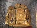
The Church contains several items that are registered as historical objects:
- An Altar, Retable, and Statue (17th century)
 [5]
[5] - An Altar, Retable, 2 Statues, and a Bust-Reliquary (17th century)[6]
- An Altar, Retable, and 2 Group Sculptures (17th century)[7]
- A Statue: Virgin and child (15th century)[8]
- A Retable in the main Altar (18th century)[9]
- 2 Sarcophagii (11th century)[10]
Views of Apchon
-
 Parish church
 -
 Church interior
 -
 Ruins of the castle (built between 1408 and 1422)
 -
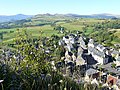 View of the village from the castle


See also
External links
- Apchon on the National Geographic Institute website Template:Fr icon
- Apchon on Lion1906
- Apchon on Google Maps
- Apchon on Géoportail, National Geographic Institute (IGN) website Template:Fr icon
- Apchon on the 1750 Cassini Map
- Apchon on the INSEE website Template:Fr icon
- INSEE Template:Fr icon
Notes and references
Notes
- ^ At the beginning of the 21st century, the methods of identification have been modified by Law No. 2002-276 of 27 February 2002 Archived 6 March 2016 at the Wayback Machine, the so-called "law of local democracy" and in particular Title V "census operations" allows, after a transitional period running from 2004 to 2008, the annual publication of the legal population of the different French administrative districts. For communes with a population greater than 10,000 inhabitants, a sample survey is conducted annually, and the entire territory of these communes is taken into account at the end of the period of five years. The first "legal population" after 1999 under this new law came into force on 1 January 2009 and was based on the census of 2006.
References
- ^ Inhabitants of Cantal Template:Fr icon
- ^ a b Google Maps
- ^ List of Mayors of France
- ^ Ministry of Culture, Mérimée PA15000047 Château fort d'Apchon Template:Fr icon
- ^ Ministry of Culture, Palissy PM15000056 Altar, Retable, and Statue Template:Fr icon

- ^ Ministry of Culture, Palissy PM15000055 Altar, Retable, 2 Statues, and a Bust-Reliquary Template:Fr icon
- ^ Ministry of Culture, Palissy PM15000054 Altar, Retable, and 2 Group Sculptures Template:Fr icon
- ^ Ministry of Culture, Palissy PM15000053 Statue: Virgin and child Template:Fr icon
- ^ Ministry of Culture, Palissy PM15000052 Retable in the main Altar Template:Fr icon
- ^ Ministry of Culture, Palissy PM15000051 2 Sarcophagii Template:Fr icon