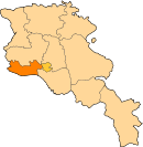
Araks, Armavir
Appearance
- For the other village of this name in Armavir province, see Araks, Armavir (east).
40°05′35″N 43°57′03″E / 40.09306°N 43.95083°E
Araks
Արաքս | |
|---|---|
 Araks village as seen from Sardarapat Monument | |
| Country | Armenia |
| Marz (Province) | Armavir |
| Founded | 1946 |
| Population (2011) | |
| • Total | 2,113 |
| Time zone | UTC+4 ( ) |
Araks (Armenian: Արաքս), is a village in the western part of the Armavir Province of Armenia. It was founded as a state farm in 1940. The Battle of Sardarapat of 1918, took place near the village of Araks. In 1968, the Sardarapat Battle Memorial was erected on the site of the battle.
 |
References
- World Gazeteer: Armenia – World-Gazetteer.com
- Report of the results of the 2001 Armenian Census, Statistical Committee of Armenia
- Kiesling, Brady (June 2000). Rediscovering Armenia: An Archaeological/Touristic Gazetteer and Map Set for the Historical Monuments of Armenia (PDF). Archived (PDF) from the original on 6 November 2021.

