Balambu
Appearance
Balambu
बलम्बु | |
|---|---|
Village of Chandragiri Municipality | |
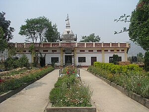
 Pranidhipurna Mahavihar in Balambu | |
| Coordinates: 27°42′N 85°15′E / 27.700°N 85.250°E | |
| Country | |
| Province | No. 3 |
| District | Kathmandu District |
| Population (2011) | |
| • Total | 7,323 |
| • Religions | Hindu |
| Time zone | UTC+5:45 (Nepal Time) |
Balambu is a village and former Village Development Committee that is now part of Chandragiri Municipality in Kathmandu District in Province No. 3 of central Nepal. At the time of the 2011 Nepal census it had a population of 7,323 and had 1734 houses in it.[1]
Language
The language of Balambu is Nepal Bhasa's Lalitpur dialect with a few informal changes.
| Lalitpur standard dialect | Pronunciation | Balambu informal changes | Pronunciation | Meaning |
|---|---|---|---|---|
| अथे | athe | एकाः | ekaa | Like that |
| थथे | thathe | थेकाः | thekaa | Like this |
| गथे | gathe | गेकाः | gekaa | Like what |
| मखू खँ ल्हाइम्ह | makhu khan lhaaimha | गौरी | gauri | Liar |
References
- ^ "Archived copy" (PDF). Archived from the original (PDF) on 2013-07-31. Retrieved 2013-12-26.
{{cite web}}: Unknown parameter|deadurl=ignored (|url-status=suggested) (help)CS1 maint: archived copy as title (link)


