
Baltit Fort
| Baltit Fort قلعہ بلتت | |
|---|---|
 | |
  | |
| General information | |
| Town or city | Karimabad |
| Country | Gilgit-Baltistan, Pakistan |
| Coordinates | 36°19′32″N 74°40′11″E / 36.325556°N 74.669722°E |
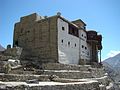
Baltit Fort (Urdu: قلعہ بلتت) is a fort in the Hunza valley, near the town of Karimabad, in the Gilgit-Baltistan region of northern Pakistan. Founded in the 8th century CE, it has been on the UNESCO World Heritage Tentative list since 2004.[1]
The Mirs of Hunza abandoned the fort in 1945, and moved to a new palace down the hill. The fort started to decay which caused concern that it might possibly fall into ruin. Following a survey by the Royal Geographical Society of London a restoration programme was initiated and supported by the Aga Khan Trust for Culture Historic Cities Support Programme. The programme was completed in 1996 and the fort is now a museum run by the Baltit Heritage Trust.[2]
Awards and recognition
[edit]Gallery
[edit]-
 Baltit Fort
 -
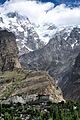
 Spantik as viewed to the south-east from the fort
 -
 Ultar Peak towers above the fort
 -
 Dance with traditional music at Baltit Fort
 -
 The fort is decorated with simple stain-glassed windows
 -
 View of Baltit Fort
 -
 Baltit Fort, Hunza Valley
 -
 The fort's historic cannon is now on display for visitors
 -
 The fort's guards wear distinctive uniforms
 -
 The fort displays local antiques
 -
 Antique Russian rifles gifted to Mir of Hunza


Bibliography
[edit]- Biddulph John, Tribes of Hindoo Koosh, The Superintendent of Government Printing-Calcutta, India 1880, Reprint: Ali Kamran Publishers, Lahore-Pakistan, 1995.
See also
[edit]References
[edit]- ^ Baltit Fort UNESCO Tentative List - official website. Retrieved 05 October 2014.
- ^ "Baltit Fort | Pakistan Tourism Portal". paktourismportal.com. Retrieved 6 August 2022.
- ^ Baker, Aryn (27 June 2005). "Best of Asia: Baltit Fort Hunza Valley, India". Time Asia. Archived from the original on 12 September 2005. Retrieved 11 December 2006.
External links
[edit]Wikimedia Commons has media related to Baltit Fort.
| Azad Kashmir |  | |
|---|---|---|
| Balochistan | ||
| Gilgit-Baltistan | ||
| Punjab |
| |
| Sindh | ||
| Khyber Pakhtunkhwa | ||