Department of Lorraine
| District of Lorraine | |||||||||||
|---|---|---|---|---|---|---|---|---|---|---|---|
| District of Alsace-Lorraine | |||||||||||
| 1871–1918/1920 | |||||||||||
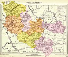
 Lorraine district with its subdistricts in different colours (1890) | |||||||||||
| Capital | Metz | ||||||||||
| Area | |||||||||||
• 1900 | 6,223 km2 (2,403 sq mi) | ||||||||||
• 1910 | 6,228 km2 (2,405 sq mi) | ||||||||||
| Population | |||||||||||
• 1900 | 564,829 | ||||||||||
• 1910 | 655,211 | ||||||||||
| Government | |||||||||||
| • Type | regional administration | ||||||||||
| Bezirkspräsident | |||||||||||
• 1871–1872 | G.H. von Donnersmarck | ||||||||||
• 1872–1873 | Botho zu Eulenburg | ||||||||||
• 1875–1876 | Robert von Puttkamer | ||||||||||
| Präsident des Bezirkstags (speaker of parl.) | |||||||||||
• 1874–1881 | Auguste-François Adam | ||||||||||
• 1881–1911 | Eduard Jaunez | ||||||||||
• 1911–1918 | Georges Ditsch | ||||||||||
| Legislature | Bezirkstag (parliament) | ||||||||||
| Historical era | 19th and 20th century | ||||||||||
• seized to Germany | 19 May 1871 | ||||||||||
10 January 1920 1918/1920 | |||||||||||
| Political subdivisions | 8 rural districts (as of 1901) 1 urban district (Metz) | ||||||||||
| |||||||||||
| Today part of | |||||||||||
| Part of a series on |
| Lorraine |
|---|
 |
Bezirk Lothringen (Template:Lang-fr;[1] i.e. Department of Lorraine), also called German Lorraine (deutsches Lothringen), was the name for a Department ("Bezirk") in the western part of Alsace-Lorraine when it was part of the German Empire from 1871 to 1918.
History
The District of Lorraine was unlike Prussian government regions no simple governorate but a corporation of self-rule of the pertaining rural and urbans subdistricts and cantons, similar to regions in the then neighbouring Bavaria (Palatinate). Thus the district parliaments delegated deputies to the General Council (parliament), the Bezirkstag von Lothringen (Template:Lang-fr). The capital of the District of Lorraine was Metz.
Territorial composition
The department comprised the districts ("Kreise") of :
- Metz, independent city (Stadtkreis)
- "Kreis Bolchen", seated in Bolchen (Boulay)
- "Kreis Château-Salins", seated in Château-Salins
- "Kreis Diedenhofen-Ost", seated in Thionville
- "Kreis Diedenhofen-West", seated in Thionville
- "Kreis Forbach", seated in Forbach
- "Kreis Metz-Land", seated in Metz
- "Kreis Saarburg",[2] seated in Sarrebourg
- "Kreis Saargemünd", seated in Sarreguemines
The district of Lorraine corresponds exactly to the current département of Moselle. After the outbreak of the Second World War and the defeat of France in 1940, the département of Moselle, renamed CdZ-Gebiet Lothringen, was added to the Gau Westmark on 30 November 1940.[3]
District Presidents
(Template:Lang-de/Template:Lang-fr)
- 1871-1872 : Guido Henckel von Donnersmarck, as préfet/Präfekt
- 1872-1873 : Botho zu Eulenburg, as department president
- 1873-1874 : Adolf von Arnim-Boitzenburg
- 1875-1876 : Robert von Puttkamer
- 1877-1880 : Friedrich Albrecht Karl Johann von Reitzenstein
- 1881-1882 : Adalbert von Flottwell
- 1883-1900 : Hans von Hammerstein-Loxten
- 1901-1912 : Johann Friedrich Alexander von Zeppelin-Aschhausen
- 1913-1918 : Karl von Gemmingen-Hornberg
References
- ^ German was the official language and its promotion was furthered, but bearing the strong proportion of French-speaking Lorrainese in mind several bilingual publications appeared especially referring to the area of their settlement in the west and south of the Department or referring to department-wide events and organisations. In official bilingual publications the Bezirk Lothringen is translated as Département de la Lorraine. Cf. the title of the department's legal gazette: Amtsblatt für den Bezirk Lothringen / Recueil officiel des actes administratifs du Département de la Lorraine.
- ^ Not to be confused with the former Rhenish Kreis Saarburg, seated in Saarburg in the Rhineland.
- ^ Jacques Lorraine (Edmond Huntzbuchler): Les Allemands en France. Origines, Bretagne, Zone interdite Est, Bourgogne, Alsace et Lorraine, Alger-Oran: editions du Désert, 1945, pp. 121–124.
Biography
- Amtsblatt für den Bezirk Lothringen / Recueil officiel des actes administratifs du Département de la Lorraine (departmental legal gazette; appeared December 1870 to 1918)
- Ernst Bruck, Das Verfassungs- und Verwaltungsrecht von Elsaß-Lothringen: 3 vols., Straßburg im Elsass: Trübner, 1908–1910.
- Stefan Fisch, „Das Elsaß im deutschen Kaiserreich (1870/71–1918)“, in: Das Elsass: Historische Landschaft im Wandel der Zeit, Michael Erbe (ed.), Stuttgart: Kohlhammer, 2003, pp. 123–146. ISBN 3-17-015771-X.
- Georg Lang, Der Regierungs-Bezirk Lothringen: statistisch-topographisches Handbuch, Verwaltung-Schematismus und Adressbuch, Metz: Lang, 1874
- Verhandlungen des Bezirkstages von Lothringen / Procès-verbaux des délibérations du Conseil Général de la Lorraine, Metz (proceedings of the departmental parliament sessions, appeared from 1874 to 1918)
External links
- "Bezirk Lothringen" on territorial.de


