Bibirevo District
Bibirevo District
Бибирево | |
|---|---|
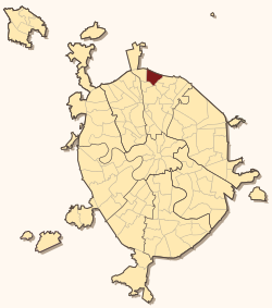
 Location of Bibirevo District on the map of Moscow | |
| Coordinates: 55°53′30″N 37°37′00″E / 55.89167°N 37.61667°E | |
| Country | Russia |
| Federal subject | Moscow |
| Time zone | UTC+3 (MSK |
| OKTMO ID | 45352000 |
| Website | http://bibirevo.mos.ru/ |
Bibirevo District (Template:Lang-ru) is an administrative district (raion) of North-Eastern Administrative Okrug near Moscow Ring Road, and one of the 125 raions of Moscow, Russia.[2] The area of the district is 6.45 square kilometers (2.49 sq mi).
History
The area is named after the village Bibirevo, known since the end of the 16th century. Until 1774 the village and the lands around it belonged to the Ascension Convent, based Dmitry Donskoy and his wife Grand Duchess Eudoxia. The monastery was located on the territory of the Moscow Kremlin and in the summer nuns traveled to Bibirevo. In 1774 the village came under the jurisdiction of the State College of economy, and peasants became state owned.
Cathedral of St. Sergius of Radonezh in Bibirevo was consecrated in 1894 in gratitude to God for the deliverance of the villagers from cholera. The temple was set flush with the wooden church of the Annunciation of the Virgin, known from the y16th centur. In 1852 in the village there were 164 farmers, 36 yards, 1 church. In 1960 was included in the Dzerzhinsky district of Moscow. Since the late 1960s its territory was subject to mass housing construction. In 1967 Bibirevo became part of the Kirovsky Raion. In 1991, after the administrative reform of some of it became separate administrative unit bearing the same name, and some - to "Altufievskoe".
See also
References
Notes
- ^ "Об исчислении времени". Официальный интернет-портал правовой информации (in Russian). 3 June 2011. Retrieved 19 January 2019.
- ^ Государственный комитет Российской Федерации по статистике. Комитет Российской Федерации по стандартизации, метрологии и сертификации. №ОК 019-95 1 января 1997 г. «Общероссийский классификатор объектов административно-территориального деления. Код 45», в ред. изменения №278/2015 от 1 января 2016 г.. (State Statistics Committee of the Russian Federation. Committee of the Russian Federation on Standardization, Metrology, and Certification. #OK 019-95 January 1, 1997 Russian Classification of Objects of Administrative Division (OKATO). Code 45, as amended by the Amendment #278/2015 of January 1, 2016. ).


