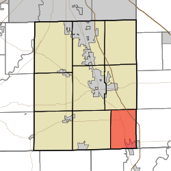
Blue River Township, Johnson County, Indiana
Appearance
Blue River Township | |
|---|---|
 | |
| Country | United States |
| State | Indiana |
| County | Johnson |
| Government | |
| • Type | Indiana township |
| Area | |
• Total | 24.44 sq mi (63.3 km2) |
| • Land | 24.28 sq mi (62.9 km2) |
| • Water | 0.16 sq mi (0.4 km2) |
| Elevation | 709 ft (216 m) |
| Population (2010) | |
• Total | 4,936 |
| • Density | 203.3/sq mi (78.5/km2) |
| FIPS code | 18-06094[2] |
| GNIS feature ID | 453120 |
Blue River Township is one of nine townships in Johnson County, Indiana. As of the 2010 census, its population was 4,936 and it contained 2,096 housing units.[3]
History
The Furnas Mill Bridge was listed on the National Register of Historic Places in 2001.[4]
Geography
According to the 2010 census, the township has a total area of 24.44 square miles (63.3 km2), of which 24.28 square miles (62.9 km2) (or 99.35%) is land and 0.16 square miles (0.41 km2) (or 0.65%) is water.[3]
References
- ^ "US Board on Geographic Names". United States Geological Survey. 2007-10-25. Retrieved 2008-01-31.
- ^ "American FactFinder". United States Census Bureau. Archived from the original on 2013-09-11. Retrieved 2008-01-31.
{{cite web}}: Unknown parameter|deadurl=ignored (|url-status=suggested) (help) - ^ a b "Population, Housing Units, Area, and Density: 2010 - County -- County Subdivision and Place -- 2010 Census Summary File 1". United States Census. Retrieved 2013-05-10.
- ^ "National Register Information System". National Register of Historic Places. National Park Service. July 9, 2010.
External links

