
Boolburra
| Boolburra Queensland | |||||||||||||||
|---|---|---|---|---|---|---|---|---|---|---|---|---|---|---|---|
 Central Western railway line crossing the Dawson River between Boolburra and Duaringa, 2017 | |||||||||||||||
 Boolburra | |||||||||||||||
| Coordinates | 23°44′07″S 149°46′58″E / 23.7352°S 149.7827°E | ||||||||||||||
| Postcode(s) | 4702 | ||||||||||||||
| Area | 320.1 km2 (123.6 sq mi) | ||||||||||||||
| Time zone | AEST (UTC+10:00) | ||||||||||||||
| Location |
| ||||||||||||||
| LGA(s) | Central Highlands Region | ||||||||||||||
| State electorate(s) | Gregory | ||||||||||||||
| Federal division(s) | Flynn | ||||||||||||||
| |||||||||||||||
Boolburra is a rural town and locality in the Central Highlands Region, Queensland, Australia.[1][2] In the 2021 census, the locality of Boolburra had a population of 34 people.[3]
Geography[edit]
The locality is bounded to the north by the Fitzroy River, to the east by the Gogango Range, to the south by the Capricorn Highway and to the west by the Dawson River.[4][5]
Boolburra has one named peak, Round Hill in the east of the locality (23°42′32″S 149°53′41″E / 23.7090°S 149.8947°E) at 230 metres (750 ft) above sea level.[6][7]
The Capricorn Highway enters the locality from the east (Gogango) and exits to the south-west (Duaringa).[5]
The Central Western railway line enters the locality from the east (Gogango) and exits to the west (Duaringa),[5] with the locality being served by three railway stations (from west to east):
- Boolburra railway station (23°44′11″S 149°46′58″E / 23.7363°S 149.7827°E)[8]
- Edungalba railway station (23°42′58″S 149°51′03″E / 23.7162°S 149.8507°E)[8]
- Tunnel railway station (23°42′03″S 149°55′21″E / 23.7009°S 149.9224°E)[8]
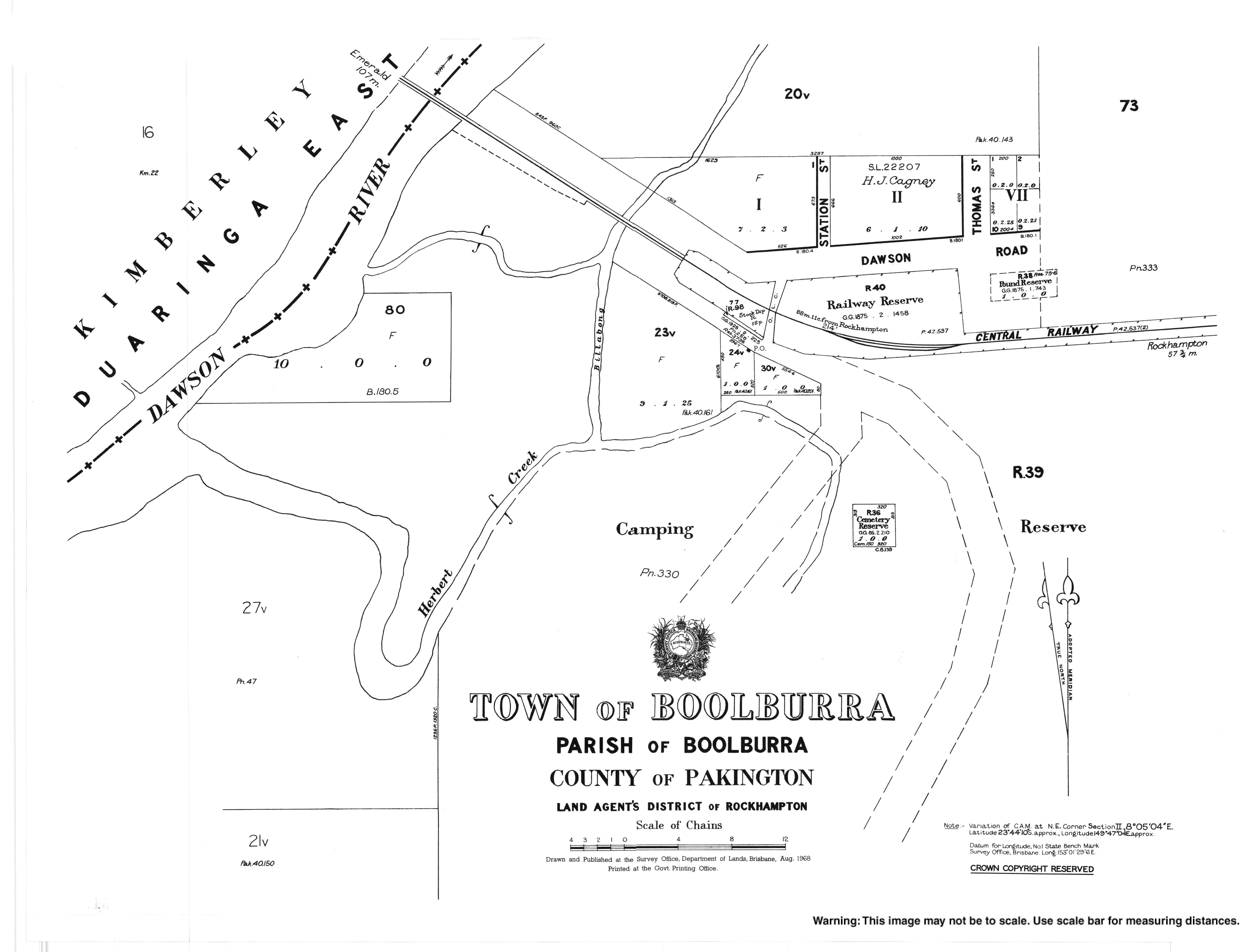
The town of Boolburra was laid out immediately north of the Boolburra railway station, but there are no buildings today.[9][10]
The town of Edungalba was laid out immediately south of the Edungalba railway station, but there are only a few buildings today.[9][10]
There is some crop growing in the west of the locality along the Dawson River, but the land use is predominantly grazing on native vegetation.[10]
History[edit]
Boolburra Provisional School opened on 31 August 1874.[11] In 1883, a school reserve of 6 acres 1 rood 10 perches (2.55 ha) was proclaimed, just north of the Boolburra railway station bounded by Station Road, Dawson Road, and Thomas Street (23°44′06″S 149°47′00″E / 23.73487°S 149.78337°E).[12][13][14] Patrick Aloysius Murtagh was school master at the school for 30 years from circa 1883 to circa 1913.[15] He also conducted a 160-acre (65 ha) agricultural farm named Gainsford at the same time.[16] On 1 January 1909, the school became Boolburra State School. It closed on 22 April 1926.[11]
Herbert's Creek State School opened on 26 April 1915, but was renamed Edungalba State School in 1918. It closed on 4 February 1974.[11] It was not in the town of Edungalba, but slightly north-west of the town between Herbert Creek and the railway line (approx 23°42′54″S 149°51′33″E / 23.71491°S 149.85919°E).[17][4][5][10]
Demographics[edit]
In the 2016 census, the locality of Boolburra had a population of 24 people.[18]
In the 2021 census, the locality of Boolburra had a population of 34 people.[3]
Education[edit]
There are no schools in Boolburra. The nearest government primary schools are Gogango State School in neighbouring Gogango to the east and Duaringa State School in neighbouring Duaringa to the west. There are no nearby secondary schools; the options are distance education and boarding school.[19]
References[edit]
- ^ "Boolburra – town in Central Highlands Region (entry 3656)". Queensland Place Names. Queensland Government. Retrieved 26 December 2020.
- ^ "Boolburra – locality in Central Highlands Region (entry 46920)". Queensland Place Names. Queensland Government. Retrieved 26 December 2020.
- ^ a b Australian Bureau of Statistics (28 June 2022). "Boolburra (SAL)". 2021 Census QuickStats. Retrieved 28 February 2023.
- ^ a b "Layers: Locality; Mountains and ranges; Contours; Watercourses". Queensland Globe. Queensland Government. Archived from the original on 19 December 2017. Retrieved 25 April 2024.
- ^ a b c d "Layers: Locality; Road and rail". Queensland Globe. Queensland Government. Archived from the original on 19 December 2017. Retrieved 25 April 2024.
- ^ "Mountain peaks and capes - Queensland". Queensland Open Data. Queensland Government. 12 November 2020. Archived from the original on 25 November 2020. Retrieved 25 November 2020.
- ^ "Round Hill – mountain in Central Highlands Region (entry 29159)". Queensland Place Names. Queensland Government. Retrieved 25 November 2020.
- ^ a b c "Railway stations and sidings - Queensland". Queensland Open Data. Queensland Government. 2 October 2020. Archived from the original on 5 October 2020. Retrieved 5 October 2020.
- ^ a b "Queensland Two Mile series sheet 2m204" (Map). Queensland Government. 1932. Retrieved 25 April 2024.
- ^ a b c d "Layers: Locality; Protected areas and forests; Land use; Land parcels". Queensland Globe. Queensland Government. Archived from the original on 19 December 2017. Retrieved 25 April 2024.
- ^ a b c Queensland Family History Society (2010), Queensland schools past and present (Version 1.01 ed.), Queensland Family History Society, ISBN 978-1-921171-26-0
- ^ "OFFICIAL NOTIFICATIONS". The Brisbane Courier. Vol. XXXVIII, no. 8, 067. Queensland, Australia. 17 November 1883. p. 6. Retrieved 25 April 2024 – via National Library of Australia.
- ^ "County of Pakingham" (Map). Queensland Government. 1921. Archived from the original on 25 April 2024. Retrieved 25 April 2024.
- ^ "Town map of Boolburra" (Map). Queensland Government. 1968. Archived from the original on 4 January 2018. Retrieved 25 April 2024.
- ^ "PERSONAL NEWS". Morning Bulletin. No. 18, 381. Queensland, Australia. 17 December 1923. p. 7. Archived from the original on 25 April 2024. Retrieved 21 April 2024 – via National Library of Australia.
- ^ "Advertising". Morning Bulletin. Vol. XLII, no. 8224. Queensland, Australia. 28 December 1889. p. 1. Archived from the original on 25 April 2024. Retrieved 21 April 2024 – via National Library of Australia.
- ^ "Parish of Boolburra" (Map). Queensland Government. 1962. Archived from the original on 25 April 2024. Retrieved 25 April 2024.
- ^ Australian Bureau of Statistics (27 June 2017). "Boolburra (SSC)". 2016 Census QuickStats. Retrieved 20 October 2018.
- ^ "Queensland Globe". State of Queensland. Retrieved 12 June 2022.