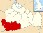
Borough of Waverley
Borough of Waverley | |
|---|---|
 Waverley shown within Surrey | |
| Sovereign state | United Kingdom |
| Constituent country | England |
| Region | South East England |
| Non-metropolitan county | Surrey |
| Status | Non-metropolitan district |
| Admin HQ | Godalming |
| Incorporated | 1 April 1974 |
| Government | |
| • Type | Non-metropolitan district council |
| • Body | Waverley Borough Council |
| • Leadership | Leader & Cabinet (No overall control) |
| • MPs | Jeremy Hunt Anne Milton |
| Area | |
| • Total | 133.3 sq mi (345.2 km2) |
| • Rank | 104th (of 296) Highest point = Gibbet Hill, Hindhead |
| Population (2022) | |
| • Total | 130,063 |
| • Rank | 183rd (of 296) |
| • Density | 980/sq mi (380/km2) |
| • Ethnicity | 97.4% White |
| Time zone | UTC0 (GMT) |
| • Summer (DST) | UTC+1 (BSTa) |
| ONS code | 43UL (ONS) E07000216 (GSS) |
| OS grid reference | SU9660743750 |
| Website | www |
The Borough of Waverley is a local government district with borough status in Surrey, England. The borough's headquarters are in the town of Godalming, with Farnham (2001 Census Pop. 37,055) and Haslemere (2001 Census Pop. 15,612) being the other large notable towns.
Waverley neighbours the boroughs of Guildford and Mole Valley in Surrey, and the counties of West Sussex and Hampshire. The borough is named after Waverley Abbey, near Farnham, the earliest Cistercian monastery in Britain. The borough in the north contains Blackheath Common an Area of Outstanding Natural Beauty.
Waverley is a Wealden (meaning wooded) borough, bounded to the north by the Hog's Back section of the North Downs and by the Greensand Ridge. It has the most green space in absolute terms in Surrey at 293.1 km² according to the central government-compiled Generalised Land Use database of January 2005, approximately half of which is woodland.[1]
Much of the west of the borough echoes former ownership by the abbey, such as Waverley Cricket Club and the Waverley Arms pubs in Farnham and elsewhere.[2] Equally echoed are the tens of square miles held under Farnham holding of the Bishop of Winchester which took in the western parishes of Frensham and Churt as well as much of Farnham parish since the early 12th century when one such Bishop, Henry of Winchester and of Blois established Farnham Castle as the See's episcopal home but which is today the borough's main surviving castle and a museum to the period.
Politics
The district was formed on 1 April 1974, under the Local Government Act 1972, by a merger of the municipal borough of Godalming, with Farnham and Haslemere urban districts and Hambledon Rural District.
Since 2001 the Council has had a Leader and cabinet on the strong leader model, while continuing with a ceremonial Mayor who chairs meetings of the Council. Mayors are elected for a one-year term, but the Leader is now elected for the full four-year term of the Council, or until standing down, if sooner. The Council has had twelve Leaders in its 42-year history, the longest serving being Robert Knowles (Conservative), who served for six years.
The May 2015 borough elections produced 53 Conservative seats, 3 Farnham Residents and one Independent. Conservatives have run the Council since 2007, winning three consecutive elections, becoming the first party in the Borough to retain control, as before 2007 the control changed at each election.
Demographics
A Legatum Prosperity Index published by the Legatum Institute in October 2016 showed Waverley as the most prosperous council area in the United Kingdom.[3]
Twinning
 Mayen-Koblenz in Germany dates from 1977.[4]
Civil parishes
Waverley is entirely divided into civil parishes.[5]
- Alfold
- Bramley
- Busbridge
- Chiddingfold
- Churt
- Cranleigh
- Dockenfield
- Dunsfold
- Elstead
- Ewhurst
- Farnham
- Frensham
- Godalming
- Hambledon
- Hascombe
- Haslemere
- Peper Harow
- Thursley
- Tilford
- Witley
- Wonersh

See also
References
- ^ Physical Environment: Land Use Statistics. (2011 census and 2001 census) Retrieved 2015-03-27.
- ^ Waverley Cricket Club official website
- ^ Emily Chan, Jessica Duncan, It's wonderful in Waverley but hell in Hull! League table of most prosperous places to live show it's grim up north - but how does your town rate? in Daily Mail online dated 22 October 2016, accessed 22 October 2016
- ^ Waverley twinning info Archived October 11, 2007, at the Wayback Machine
- ^ Surrey County Council

