
Cascade River State Park
Cascade River State Park is a state park near the northeastern tip of Minnesota, USA, on the north shore of Lake Superior. The park is in a rocky and rugged location, and has many different types of wildlife.
Cascade River State Park is also connected to the Superior Hiking Trail.
The site was originally named Cascade River State Wayside. It was developed by the Civilian Conservation Corps starting around July 1934. One of the projects was a huge 535 feet (163 m) overlook wall, built from locally quarried gabbro.[1] The roadside development plans were drawn by Arthur R. Nichols and Harold E. Olson. The project was considered a model for roadside development. The development work was supervised and inspected not just by National Park Service employees, but also by members of the Minnesota Highway Department, staff of the Minneapolis Park Board, Civilian Conservation Corps individuals, members of the Minnesota Legislature, and some Canadian officials.[2] The wayside was listed on the National Register of Historic Places on August 4, 2003.[3]
Gallery
-
 The Cascade River.
 -
 The Cascade River.
 -
 A rainbow over the Cascade River.
 -
 A rainbow over the Cascade River.
 -
 The Cascade River.
 -
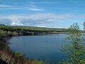 Lake Superior just South of Cascade River State Park.

.JPG)
.JPG)
.JPG)
.JPG)
.JPG)
References
- ^ Gardner, Denis P. (2004). Minnesota Treasures: Stories Behind the State's Historic Places. St. Paul, Minnesota: Minnesota Historical Society. pp. 262–266. ISBN 0-87351-471-8.
{{cite book}}: Cite has empty unknown parameter:|coauthors=(help) - ^ "MN/DOT Historic Roadside Development Structures Inventory: Cascade River Overlook" (PDF). December 1998. Retrieved 2013-03-27.
- ^ "National Register Information System". National Register of Historic Places. National Park Service. July 9, 2010.
External links
This article about a location in Cook County, Minnesota is a stub. You can help Wikipedia by expanding it. |
This article about a property in Minnesota on the National Register of Historic Places is a stub. You can help Wikipedia by expanding it. |
- 1957 establishments in Minnesota
- Park buildings and structures on the National Register of Historic Places in Minnesota
- Protected areas established in 1957
- Protected areas of Cook County, Minnesota
- State parks of Minnesota
- National Register of Historic Places in Cook County, Minnesota
- Cook County, Minnesota geography stubs
- Minnesota Registered Historic Place stubs