
Castelnou, Pyrénées-Orientales
Castelnou | |
|---|---|
 View of Castelnou and its castle | |
.svg) Coat of arms | |
Location of Castelnou  | |
| Country | France |
| Region | Occitania |
| Department | Pyrénées-Orientales |
| Arrondissement | Perpignan |
| Canton | Les Aspres |
| Intercommunality | Aspres |
| Government | |
| • Mayor (2014-2020) | Jean Cherez |
| Area 1 | 19.28 km2 (7.44 sq mi) |
| Population (2013) | 341 |
| • Density | 18/km2 (46/sq mi) |
| Time zone | UTC+01:00 (CET) |
| • Summer (DST) | UTC+02:00 (CEST) |
| INSEE/Postal code | 66044 /66300 |
| Elevation | 111–444 m (364–1,457 ft) |
| 1 French Land Register data, which excludes lakes, ponds, glaciers > 1 km2 (0.386 sq mi or 247 acres) and river estuaries. | |
Castelnou (Catalan: Castellnou dels Aspres) is a commune in the Pyrénées-Orientales department in southern France.
Geography
Castelnou is located in the canton of Thuir and in the arrondissement of Perpignan.

Population

Sites of interest
- Château de Castelnou : the medieval castle.
- The old village, labelled as Plus Beaux Villages de France.
- The church of Sainte-Marie du Mercadal, from the 13th century.
- The tower of Castelnou, a former watch tower.
Gallery
-
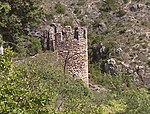 A tower of the castle
 -
 The church of Sainte-Marie du Mercadal
 -
 A street in the village
 -
 The village seen from the castle


See also
References
Wikimedia Commons has media related to Castelnou.
This Pyrénées-Orientales geographical article is a stub. You can help Wikipedia by expanding it. |