Cerić, Croatia
Appearance
Cerić | |
|---|---|
 | |
| Coordinates: 45°18′40″N 18°51′23″E / 45.311151°N 18.856404°E | |
| Country | |
| County | |
| Municipality | Nuštar |
| Area | |
| • Total | 13.9 km2 (5.4 sq mi) |
| Population (2021)[2] | |
| • Total | 1,292 |
| • Density | 93/km2 (240/sq mi) |
| Time zone | UTC+1 (CET) |
| • Summer (DST) | UTC+2 (CEST) |
| Postal code | 32221 Nuštar |

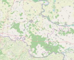
Cerić is a village in eastern Croatia, located to the northeast of Vinkovci.
Cerić was first mentioned in historical documents in 1267, as part of the Monoštar estate. Today, Cerić is part of the Nuštar municipality.[3]
During the Croatian War of Independence, Cerić was on the eastern front, and it was occupied by Serbian forces on October 2, 1991, to the detriment of the Croatian civilian population.[4]
References
[edit]- ^ Register of spatial units of the State Geodetic Administration of the Republic of Croatia. Wikidata Q119585703.
- ^ "Population by Age and Sex, by Settlements" (xlsx). Census of Population, Households and Dwellings in 2021. Zagreb: Croatian Bureau of Statistics. 2022.
- ^ "Cerić - Općina Nuštar" (in Croatian). 2021-04-07. Retrieved 2023-02-02.
- ^ "Obilježeno stradanje Cerića tijekom Domovinskog rata" (in Croatian). Braniteljski portal. October 2, 2009. Archived from the original on July 21, 2011. Retrieved 2010-09-12.


