
Chafarinas Islands
 | |
| Geography | |
|---|---|
| Location | Mediterranean sea |
| Administration | |
Spain | |

The Chafarinas Islands (Spanish: Islas Chafarinas IPA: [ˈizlas tʃafaˈɾinas], Berber: Igumamen Iceffaren or Takfarinas, Arabic: جزر الشفارين or الجزر الجعفرية), also spelled Zafarin, Djaferin[1] or Zafarani,[2] are a group of three small islets located in the Alboran Sea off the coast of Morocco with an aggregate area of 0.525 square kilometres (0.203 sq mi), 45 km (28.0 mi) to the east of Nador and 3.3 km (2.1 mi) off the Moroccan town of Ras Kebdana.
The Chafarinas Islands are one of the Spanish territories on North Africa off the Moroccan coast known as plazas de soberanía.
Geography
The Chafarinas Islands are made up of three islands (from west to east, with areas in hectares):
- Isla del Congreso (25.6 ha)
- Isla Isabel II (15.3 ha) (with garrison)
- Isla del Rey (11.6 ha)
Under Spanish control since 1847, there is a 190-man military garrison on Isla Isabel II, the only stable population on the small archipelago, down from 426 people in 1900 and 736 people in 1910.
The islands had a certain relevance in Spanish environmentalist circles during the 1980s and 1990s as the very last individual of Mediterranean monk seal in Spanish territory lived there, until it disappeared in the 1990s.[3] Nine out of eleven marine invertebrates considered endangered species and the second largest colony in the world of the endangered Audouin's gull inhabit the islands.[4]
Gallery
-
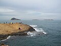 Islas Chafarinas as seen from Cabo de Agua
 -
 Audouin's gull, one of the numerous inhabitants on the islands
 -
 Island of Isabel II
 -
 Church on the island of Isabel II in 1893
 -
 Coat of arms of the Chafarinas Islands
 -


_en_1893.jpg)


See also
References
- ^ "Chafarinas Islands". Encyclopædia Britannica. 2011. Retrieved September 7, 2011.
- ^ "Index of Countries and Localities". USPS. 2011. Retrieved September 7, 2011.
- ^ Foca monje del Mediterráneo | CONSUMER.es EROSKI
- ^ Ceberia, Monica et al (17 September 2012) The last remains of the empire El Pais in English, Retrieved 24 September 2012
Countries and territories of North Africa | |||||||||||||||||
|---|---|---|---|---|---|---|---|---|---|---|---|---|---|---|---|---|---|
| Sovereign states | |||||||||||||||||
| Partially recognized state | |||||||||||||||||
| Territories |
| ||||||||||||||||
1Entirely claimed by both Morocco and the SADR. 2Spanish exclaves claimed by Morocco. 3Portuguese archipelago claimed by Spain. 4Disputed between Egypt and the Sudan. 5Unclaimed territory located between Egypt and the Sudan. 6Disputed between South Sudan and the Sudan. 7Part of Chad, formerly claimed by Libya. 8Disputed between Morocco and Spain | |||||||||||||||||