
Charles de Gaulle–Étoile station
Charles de Gaulle–Étoile | |||||||||||||||||||||||||||||||
|---|---|---|---|---|---|---|---|---|---|---|---|---|---|---|---|---|---|---|---|---|---|---|---|---|---|---|---|---|---|---|---|
| Paris Métro and RER station | |||||||||||||||||||||||||||||||
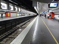
 Line 2 platforms. | |||||||||||||||||||||||||||||||
| General information | |||||||||||||||||||||||||||||||
| Location | |||||||||||||||||||||||||||||||
| Coordinates | 48°52′26″N 2°17′42″E / 48.873933°N 2.2949°E | ||||||||||||||||||||||||||||||
| Owned by | RATP Group | ||||||||||||||||||||||||||||||
| Operated by | RATP Group | ||||||||||||||||||||||||||||||
| Line(s) | Lua error: expandTemplate: template "PM color" does not exist. Lua error: expandTemplate: template "PM color" does not exist. Lua error: expandTemplate: template "PM color" does not exist. Lua error: expandTemplate: template "RER color" does not exist. | ||||||||||||||||||||||||||||||
| Platforms | 2 (Line 1) / 2 (Line 2) / 2 (Line 6) 2 (RER A) | ||||||||||||||||||||||||||||||
| Tracks | 2 (Line 1) / 2 (Line 2) / 1 (Line 6) 2 (RER A) | ||||||||||||||||||||||||||||||
| Other information | |||||||||||||||||||||||||||||||
| Fare zone | 1 | ||||||||||||||||||||||||||||||
| History | |||||||||||||||||||||||||||||||
| Opened | 1 September 1900 (Line 1) 13 December 1900 (Line 2) 6 October 1942 (Line 6) 19 January 1970 (RER A) | ||||||||||||||||||||||||||||||
| Previous names | Étoile (1900-1970) | ||||||||||||||||||||||||||||||
| Passengers | |||||||||||||||||||||||||||||||
| 2015 | 8,495,803 (RER A) | ||||||||||||||||||||||||||||||
| Services | |||||||||||||||||||||||||||||||
| |||||||||||||||||||||||||||||||
Charles de Gaulle–Étoile is a station of the Paris Métro and of Île-de-France's regional high-speed RER. It serves lines 1, 2, 6 of the Paris Métro and line A of the RER and lies on the boundary of the 8th, 16th, and 17th arrondissements of Paris. Originally called simply Étoile, after its location at Place de l'Étoile, it took on the additional name of President Charles de Gaulle from 1970.
The station serves as the western terminus of Paris Métro Line 6. The platforms are built beneath Place de l'Étoile, which is situated at the western end of the Avenue des Champs-Élysées. The Arc de Triomphe is located in the center of the Place. Lines 1 and 2 have two side platforms each, while the terminus on Line 6 is a single track with two platforms situated in a loop; passengers alight on the left platform and board on the right. Trains depart immediately from this station and make a longer stop at Kléber.
History
Although Line 1 had opened on 19 July 1900, Étoile station only opened on 1 September that year, being followed quickly by the Line 6 station (on 2 October) and the line 2 station (on 13 December; this station was initially the terminus of a shuttle from Porte Dauphine before the line was extended to Anvers on 7 October 1902). The RER line A station, 30 m deeper, opened on 21 February 1970, initially as the terminus of a shuttle from La Défense. After the death of Charles de Gaulle on 13 November 1970, Place de l'Étoile was renamed Place Charles de Gaulle and the station was renamed as Charles de Gaulle–Étoile. The RER was extended to Auber on 23 November 1971.[1]
Station layout
| Street level | Accesses | |
| B1 | Mezzanine for platform connection, passageway to RER platforms | |
| B2 | Side platform with PSDs, doors will open on the right | |
| Westbound | ← | |
| Eastbound | | |
| Side platform with PSDs, doors will open on the right | ||
| Side platform, doors will open on both sides (boarding platform) | ||
| Southbound | ← | |
| Side platform, doors will open on both sides (alighting platform) | ||
| B3 | Side platform, doors will open on the right | |
| Southbound | ← | |
| Northbound | | |
| Side platform, doors will open on the right | ||
Gallery
Métro
-
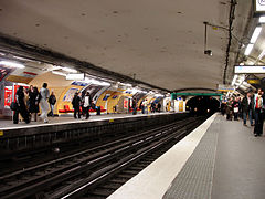 Line 1 platforms.
 -
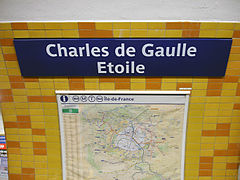 Sign in the station.
 -
 Line 6 platforms. Note the spanish solution platform layout.


RER
-
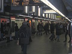 RER A platforms in 2005.
 -
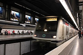 MI 2N at Charles de Gaulle - Étoile.
 -
 RER A platforms in 2015.
 -
 MI 09 at Charles de Gaulle - Étoile.


See also
References
- ^ Gérard, Roland (2003). Stations de métro. D’Abbesses à Wagram. Éditions Bonneton.
| Stations | |
|---|---|
- Use dmy dates from April 2011
- Paris Métro line 1
- Paris Métro line 2
- Paris Métro line 6
- Paris Métro stations in the 16th arrondissement of Paris
- Paris Métro stations in the 17th arrondissement of Paris
- Paris RER stations
- Railway stations opened in 1900
- Paris Métro stations in the 8th arrondissement of Paris
- Charles de Gaulle
- 1900 establishments in France
- Railway stations located underground in France