Cilcain
| Cilcain | |
|---|---|
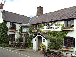
 The White Horse Inn, in the Village Centre | |
Location within Flintshire | |
| Population | 1,378 (2011)[1] |
| OS grid reference | SJ1765 |
| Community |
|
| Principal area | |
| Preserved county | |
| Country | Wales |
| Sovereign state | United Kingdom |
| Post town | MOLD |
| Postcode district | CH7 |
| Dialling code | 01352 |
| Police | North Wales |
| Fire | North Wales |
| Ambulance | Welsh |
| UK Parliament | |
| Senedd Cymru – Welsh Parliament | |
Cilcain is a village and community, near Mold in Flintshire, north-east Wales. The village has an industrial history and includes the Millennium Woods, a post office, a public house, a parish church, a primary school (Ysgol y Foel) and a village hall.
Cilcain borders the parishes of Rhosesmor, Rhes-y-cae and Rhydymwyn.
The community includes the village of Rhydymwyn.
Name
The Welsh placename Cilcain, which has also in the past been spelled as Kilken and Cilcen, has been suggested to derive from cil meaning 'retreat' and cain meaning 'fair' or 'pleasant' in the Welsh language.
Early Cilcain
In the early years of Cilcain's existence it was noted as a place of retreat and was also locally famous for its regular village fairs, where a notable amount of alcohol was often consumed. Cilcain was also known for cockfighting, which took place on Sundays after the local church service.
Church
The first recorded mention of the church at Cilcain dates from 1291. Cilcain is one of the "ancient parishes" of Flintshire. It originally comprised the seven townships of Cefn, Llan (or Tre'r Llan), Llystynhunydd (or Glust), Llys y Coed, Maes y Groes, Mechlas (or Dolfechlas), and Trellyniau. On 27 June 1848, the township of Trellyniau and part of the township of Llystynhunydd went to the new parish of Rhes-y-Cae. On 31 March 1865, the remainder of Llystynhunydd, and parts of the townships of Cefn and Mechlas, went to the new parish of Rhydymwyn.
Governance
An electoral ward in the same name exists. This ward stretches north and had a total population at the 2011 Census of 1,874.[2]
Millennium Woods
The Millennium Woods were planted in 2000 through the 'Woods on your doorstep' scheme of the Woodland Trust. Many of the trees were planted by some of the students attending the local school, Ysgol y Foel, in that year. The official name is Coed y Felin ('Mill Woods'), named after the disused mill that now lies in ruins by the stream below.
See also
- Cilcain Hall
- Brynle Williams (1949–2011), Cilcain farmer and Conservative member of the National Assembly for Wales.
References
- ^ "Community population 2011". Retrieved 25 May 2015.
- ^ "Ward population 2011". Retrieved 25 May 2015.


