
Cold Spring Harbor station
Cold Spring Harbor | |||||||||||||||||||||
|---|---|---|---|---|---|---|---|---|---|---|---|---|---|---|---|---|---|---|---|---|---|
 Cold Spring Harbor station | |||||||||||||||||||||
| General information | |||||||||||||||||||||
| Location | West Pulaski Road & East Gate Drive West Hills, New York | ||||||||||||||||||||
| Coordinates | 40°50′06″N 73°27′06″W / 40.835056°N 73.451611°W | ||||||||||||||||||||
| Owned by | Long Island Rail Road | ||||||||||||||||||||
| Line(s) | |||||||||||||||||||||
| Platforms | 2 side platforms | ||||||||||||||||||||
| Tracks | 2 | ||||||||||||||||||||
| Connections | NYS Bike Route 25A[1] | ||||||||||||||||||||
| Construction | |||||||||||||||||||||
| Parking | Yes; Town of Huntington residential permits | ||||||||||||||||||||
| Bicycle facilities | Yes; Bike Racks and Lockers | ||||||||||||||||||||
| Accessible | Yes | ||||||||||||||||||||
| Other information | |||||||||||||||||||||
| Fare zone | 9 | ||||||||||||||||||||
| History | |||||||||||||||||||||
| Opened | 1901 or 1902 | ||||||||||||||||||||
| Rebuilt | 1948 | ||||||||||||||||||||
| Electrified | October 19, 1970 750 V (DC) third rail | ||||||||||||||||||||
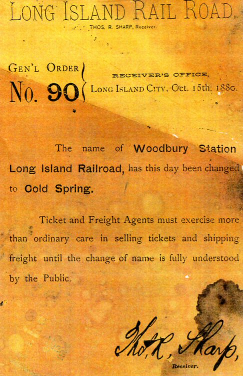
| Previous names | Woodbury (1875–1880) | ||||||||||||||||||||
| Passengers | |||||||||||||||||||||
| 2006 | 4,166[2] | ||||||||||||||||||||
| Services | |||||||||||||||||||||
| |||||||||||||||||||||
Cold Spring Harbor is a station on the Long Island Rail Road's Port Jefferson Branch at West Pulaski Road and East Gate Drive, just south of Woodbury Road in West Hills, New York. It is the westernmost station along the Port Jefferson Branch in Suffolk County. This train station is located in the South Huntington Union Free School District, and serves the hamlets of Cold Spring Harbor and West Hills in the town of Huntington.
History
A station was built in Nassau (then Queens) County in December 1875 in Woodbury as "Woodbury station", as an extension of the Hicksville and Syosset Railroad. It was renamed "Cold Spring station" on October 15, 1880,[3] although Cold Spring Harbor is across the Suffolk County Line. Sometime between 1901 and 1902 it was moved east to Cold Spring Harbor, and given its current name. The station was razed then rebuilt in 1948.[4] In 1970 the station was electrified, along with the rest of the Port Jefferson Branch between Mineola and Huntington stations.[5] Since 2007, the station has served as the western terminus of New York State Bicycle Route 25A.
Station layout
The station has two high-level side platforms. Platform A is 12 cars long and Platform B is eight cars long. During the evening rush hours, some eastbound trains use Platform A.
| Ground/platform level Exit/entrance | |
| Platform A, doors will open on the right | |
| Track 1 | ← Port Jefferson Branch toward Jamaica, Atlantic or Penn Station (Syosset) |
| Track 2 | Port Jefferson Branch toward Huntington or Port Jeff (Huntington) |
| Platform B, doors will open on the right | |
References
- ^ State Bike Route 25A (Bicycling in New York; NYSDOT)
- ^ Average weekday, 2006 LIRR Origin and Destination Study
- ^ Long Island Rail Road: General Order Number 90 (TrainsAreFun.com)
- ^ LIRR station History (TrainsAreFun.com)
- ^ Bamberger, Werner (October 20, 1970). "Change at Jamaica Is Only a Memory For 12,000 Riders". The New York Times. p. 88. Retrieved 2009-09-17.
External links
- Cold Spring Harbor – LIRR
- Cold Spring Harbor LIRR timetable
- Hicksville & Cold Spring Harbor Branch Map; 1855 (Arrt's Arrchives)
- Cold Spring Harbor LIRR station (The Subway Nut)
- Unofficial LIRR History Website
This New York train station–related article is a stub. You can help Wikipedia by expanding it. |