
Continental Divide of the Americas
- For continental divides in general, see Continental divide.


The Continental Divide of the Americas, or merely the Continental Divide or Great Divide, is the name given to the principal, and largely mountainous, hydrological divide of the Americas that separates the watersheds that drain into the Pacific Ocean from (1) those river systems that drain into the Atlantic Ocean (including those that drain via the Gulf of Mexico or the Caribbean Sea), and (2) along the northernmost reaches of the Divide, those river systems that drain into the Arctic Ocean.
There are other continental divides on the North American continent, however the Great Divide is by far the most prominent of these because it tends to follow a line of high peaks along the main ranges of both the American and Canadian Rocky Mountains, at a generally much higher elevation than the other divides.
Geography
The Continental Divide of the Americas begins at Cape Prince of Wales, Alaska, the westernmost point on the mainland of the Americas. The Divide crosses northern Alaska into the Yukon, then zig-zags south into British Columbia via the Cassiar Mountains and Omineca Mountains and northern Nechako Plateau to Summit Lake, north of the city of Prince George and just south of the community of Mcleod Lake. From there the Divide traverses the McGregor Plateau to the spine of the Rockies, following the crest of the Canadian Rockies southeast to the 120th meridian west, from there forming the boundary between southern British Columbia and southern Alberta.
The Divide crosses into the United States in northwestern Montana, at the boundary between Waterton Lakes National Park and Glacier National Park, and bisects both parks. The Divide heads south towards Butte, then west to the Bitterroot Range, where it forms the eastern third of the state boundary between Idaho and Montana. The Divide crosses into Wyoming at Yellowstone National Park and continues south-southeast into Colorado, then western New Mexico.
It enters Mexico along the crest of the Sierra Madre Occidental through the Mexican states of Chihuahua, Durango, Zacatecas, Aguascalientes, Jalisco, Guanajuato, Querétaro, México, the Federal District, Morelos, Puebla, Oaxaca, and Chiapas; thence through southern Guatemala, southwestern Honduras, western Nicaragua, and western/southwestern Costa Rica, and southern Panama.
The Divide continues into South America, where it follows the peaks of the Andes Mountains, traversing western Colombia, central Ecuador, western and southwestern Peru, and eastern Chile (essentially conforming to the Chile-Bolivia and Chile-Argentina boundaries), southward to the southern end of Patagonia and Tierra del Fuego.
In North America, a pair of secondary, non-mountainous divides further separate other river systems that drain into the Arctic Ocean and those that drain into Hudson Bay, James Bay, and Ungava Bay, which open into the North Atlantic, from those that drain into the Atlantic Ocean to the south of Labrador (including those that drain via the Great Lakes and Saint Lawrence Seaway).
Triple points
Triple Divide Peak, in Glacier National Park, Montana, is the point at which two of the principal continental divides in North America converge, the Great Divide and the Northern Divide. From this point, waters flow to the Pacific Ocean, the Atlantic Ocean via the Gulf of Mexico, and the Arctic Ocean via Hudson Bay. Most geographers, geologists, meteorologists, and oceanographers generally consider this point to be the hydrological apex of North America. This is the only place on earth where two oceanic divides meet, i.e., where waters from a single point area feed into three different oceans. This status of Triple Divide Peak is the main reason behind the designation of Glacier-Waterton International Peace Park as the "Crown of the Continent" of North America[1]
Another triple divide or triple point occurs in Canada on a prominent peak directly on the border between Alberta and British Columbia, called Snow Dome because the Columbia Icefield completely covers the summit.[2] From this peak, water flows into the Pacific Ocean via the Columbia River system; the Arctic Ocean via the Athabasca River and MacKenzie River systems; and Hudson Bay via the North Saskatchewan River system. Canadians generally consider Snow Dome to be the hydrological apex of North America because they consider Hudson Bay to be an extension of the Atlantic Ocean, and also because Snow Dome is 1,000 metres (3,300 ft) higher than Triple Divide Peak.[3] The IHO, International Hydrographic Organization, lists Hudson Bay as part of the Arctic Ocean[citation needed])
In fact, there are such triple divide points wherever any two continental divides meet.[4] North America can be considered to have five major drainage systems: into the Pacific, Atlantic and Arctic Oceans, plus Hudson Bay and the Gulf of Mexico. Within this system there are four continental divides and three triple points, the two mentioned previously and a third near Hibbing, Minnesota where the Northern Divide intersects the Saint Lawrence Seaway divide.[5] Since there is no true consensus on what a continental divide is, there is no real agreement on where the triple points are.[6] However, the main Continental Divide described in this article is a far more distinctive geological feature than the others and its two main triple points are much more prominent.
Hiking Trail
The Continental Divide Trail follows the divide through the U.S. from the Mexican border to the Canadian border. A less-developed Canadian extension called the Great Divide Trail continues on through five National Parks of Canada and six provincial parks to end at Kakwa Lake in northeastern British Columbia.[7]
Exceptions
Many endorheic regions in North America complicate the simple view of east or west, "ocean-bound" water flow. The Great Basin of the western United States, the Valley of Mexico and Bolson de Mapimi in Mexico, the Tularosa Basin in New Mexico and Texas, and the Salton Trough are examples of internally draining areas. In these cases, water often drains to low basins, where sedimentation and evaporation form salt lakes, salt flats, and alkali flats.
On the Llano Estacado in Texas and New Mexico, many thousands of seasonal playa lakes form during wet months, an average of one per square mile. This region is very flat, and water mostly evaporates before draining. Zuni Salt Lake is one example of a larger, seasonal maar that does not drain to an ocean. There are a number of seasonal lakes of this sort in North America. In areas of karst topography (such as northern Florida), isolated drainages can also occur. The Great Divide Basin in Wyoming has no natural outlet except as groundwater, and hence it lies between the Atlantic and Pacific watersheds, being part of neither. Water from North Two Ocean Creek and Isa Lake in Wyoming flow into both oceans.
Images
-

-
 Winter Park Resort, a ski resort in the southeast end of Fraser Valley, located at the west end of the Moffat Tunnel, a major Union Pacific railroad tunnel under the divide
 -
 The Continental Divide as it passes through Colorado at the Loveland Pass
 -
 Grays Peak at 4,352 meters (14,278 ft) elevation in Colorado is the highest point on the Continental Divide in North America.
 -
-
 The Continental Divide viewed from northwest of Winter Park, Colorado.
 -
 Divide on US 550 in New Mexico.
 -
 Divide on I-40 in New Mexico.
 -
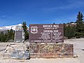 Hoosier Pass Colorado on May 29, 2006.
 -

-
 South Pass sign in Wyoming.
 -
 August, 1964 atop Loveland Pass, Colorado.


See also
- Continental divide
- Continental Divide Trail
- Great Divide Trail
- Eastern Continental Divide
- Lemhi Pass
- List of railroad crossings of the North American continental divide
- Laurentia
- Laurentian Divide (Northern Divide)
- Valparaiso Moraine
References
- ^ [1]
- ^ Birrel, Dave (2007). "Snow Dome". Peaks of the Canadian Rockes. PeakFinder (Rocky Mountain Books). Retrieved 2007-12-28.
- ^ Timmer, Henry (2006). "Snow Dome - The Hydrological Apex of North America". Snow Dome. climbwild.net. Retrieved 2007-12-28.
- ^ Andersen, Robert N. (2006). "Triple Divide Points and North American Drainage Basins". University of Wisconsin - Eau Claire. Retrieved 2007-12-29.
- ^ "Minnesota Rivers Map". Minnesota State Map Collection. Geology.com. 2006. Retrieved 2007-12-29.
- ^ Gonzalez, Mark A. (2002). "Continental Divides in North Dakota and North America" (PDF). NGDS Newsletter. North Dakota Geological Survey. Retrieved 2007-12-29.
- ^ Lynx, Dustin (2000). Hiking Canada's Great Divide Trail. Rocky Mountain Books. ISBN 0921102798.
External links
 Definitions from Wiktionary
 Media from Commons
 News from Wikinews
 Quotations from Wikiquote
 Texts from Wikisource
 Textbooks from Wikibooks
 Resources from Wikiversity
- A detailed map of watersheds in North America
- A detailed overview of isolated wetlands from the USFWS
- Detailed article, maps, and boundary data from The National Atlas of the United States
- Parting of the Waters: a creek that flows to two oceans
 | ||