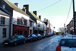
Corofin, County Clare
Corofin
Cora Finne | |
|---|---|
Town | |
 Main street | |
| Coordinates: 52°56′43″N 9°03′43″W / 52.945225°N 9.062004°W | |
| Country | Ireland |
| Province | Munster |
| County | County Clare |
| Elevation | 30 m (100 ft) |
| Population (2016)[1] | 776 |
| Time zone | UTC+0 (WET) |
| • Summer (DST) | UTC-1 (IST (WEST)) |
| Irish Grid Reference | R285887 |
Corofin (Irish: Cora Finne[2] or Coradh Finne) is a village on the River Fergus in northern County Clare, Ireland and also a parish of the same name in the Catholic Diocese of Killaloe.
The 2016 population was 776, up from 689 in 2011.[1][3]
Name
The name Corofin means "the white or foam-flecked ford" from the Template:Lang-ga, the earliest form of the name to be found in the literature: "fearann re hucht Finn Coradh".-[Ó hUidhrín, 15c. Topographical Poem]
A different translation is "Finne's weir".[4]: 15
The town is sometimes spelled "Corrofin".[2] Corofin also styles itself as "The Gateway to the Burren" or "The Angler's Paradise".
Geography
The village is 12 km (7.5 mi) north of the county town of Ennis, at the crossroads of the R460 and R476 regional roads. It is on the southern edge of the upland limestone region of The Burren. Corofin is in the civil parish of Kilnaboy in the Barony of Inchiquin.[5] It lies across the townlands of Baunkyle, Laghtagoona and Kilvoydan.
It lies in the Kilnaboy parish of the Roman Catholic Diocese of Killaloe. The parish has three churches, St Brigid's in Corofin, St Joseph's in Kilnaboy and St Mary's in Rath.[6]
Corofin is the childhood home of painter Frederick William Burton.[4]: 15
Tourism

St. Catherine's Church
On Church Street is the former Church of Ireland, St. Catherine's Church, built between 1715 and 1720 by Catherine Kneightly. It was renovated c. 1820 and by 1829 the steeple had been added.[7] The building is now in use by the Clare Heritage and Genealogical Research Centre.
An Irish National Monument, the Cross Inneenboy, also known as Roughan Hill Tau Cross, is a stone tau cross which has been moved into the centre for safe keeping.

Inchiquin Castle

Inchiquin Castle is located on the north side of Lake Inchiquin (in the parish of Kilnaboy). It was possibly begun by Teige-an-Chomhaid O'Brien (d. 1466). In 1542, it belonged to Turlough, son of Murrough, first Baron of Inchiquin. Murrough O'Brien, the fourth Baron, was in possession in 1580. His descendants, the Marquesses of Thomond, derived their title of Earl of Inchiquin from this estate. During the Nine Years' War, Hugh Roe O'Donnell raided Clare and Inchiquin Castle was attacked by one of his lieutenants, Maguire of Fermanagh. During the Confederate Wars Christopher O'Brien, Murrough the Burner's brother, lived here. Murrough's son, Colonel John O'Brien, abandoned Inchiquin towards the end of the 17th century. By then it had deteriorated into a ruin. Today the castle remains a ruin surrounded by pastures. Part of the older castle tower is still extant as is a good portion of the later 17th-century banquet hall.[7]
Town twinning
Corofin is twinned with Tonquédec in France.[citation needed]
Notable people
- Chartres Brew, 19th century Gold commissioner, Chief Constable and judge in the Colony of British Columbia
- Frederick William Burton, 19th-century painter and director of the National Gallery, London
- Tony Killeen, (born 1952), Fianna Fáil politician, former Teachta Dála (TD) for the Clare constituency and Minister for Defence
- Benjamin Lucas, soldier of the 17th century
- Gerry Quinn, Hurling left-wing back (born 1980)
See also
References
- ^ a b "Census 2016 Sapmap Area: Settlements Corrofin". Central Statistics Office (Ireland). Retrieved 21 February 2018.
- ^ a b Corrofin, County Clare Placenames Database of Ireland. Retrieved: 2011-11-22.
- ^ "Census 2011 - Table 5 Population of towns ordered by county and size, 2006 and 2011" (PDF). CSO. Archived from the original (PDF) on 4 March 2016. Retrieved 7 January 2014.
- ^ a b Roche, D. The Clare Guide - Official Irish Tourist Board Guide. Bord Failte.
- ^ "Corofin, Corrofin or Curofin". Parliamentary Gazetteer of Ireland. 1845. Retrieved 2 April 2014.
- ^ "Corofin". Diocese of Killaloe. Archived from the original on 7 April 2014. Retrieved 31 March 2014.
- ^ a b "Corofin, Places of Interest". Clare County Library. Retrieved 2 January 2017.
- Sources
- Michael Mac Mahon, The Parish of Corofin: A Historical Profile, ISBN 978-0-953866724.


